
Related
Final Stop-Work order in Al-Khader /Bethlehem
Violation: final demolishing order for a house.
Location: Al-Khader/ Bethlehem
Date: August 21, 2018.
Perpetrators: The occupation military forces and civil administration.
Victims: Sameer Ahmad Salah family.
Description:
The Israeli Occupation military forces broke into Al-Khader and delivered military order to citizen Sameer Salah to demolish his under-construction home in the pretext of unauthorized building. The order requests to immediately stop working and demolishing what was built within 7 days from the day the order is received, in case of not carrying out what the order requests, The Israeli military occupation will demolish the construction and the owner will have to pay expensive fine.
Iyad from Al-Khader municipality told LRC observer:
"when the family received the military order, they immediately filed the necessary legal documents to the occupation's court, but the occupation insist on demolishing any Palestinian home in that area"
The following chart provides additional information:
Owner's name
|
Total area m2
|
Family members
|
children
|
Status of the building
|
Order number
|
Sameer Ahmad Salah
|
120
|
6
|
4
|
Under construction
|
509338
|
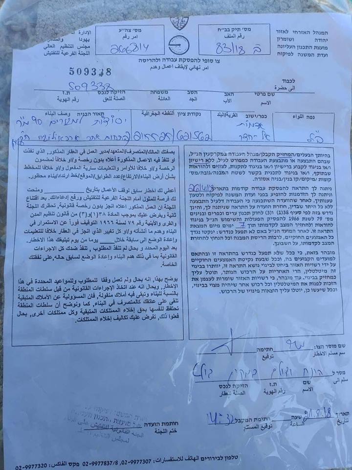
Final order to demolish Salah family home
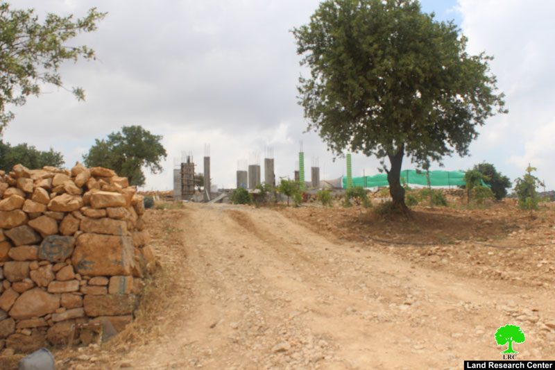
Salah under-construction family home
In reality, it is not about unauthorized building, Salah family home is built close to "Efrat" illegal settlement in Al-Khader Palestinian village, The occupation destroys any new constructions in that area attempting to take over surrounding lands.
About Al-Khader village[1]:
Al-Khader village is located 4 km from the western side of Bethlehem, it is bordered by Beit Jala and Batir from the north, Hussan and Nahaleen villages from the west, Aldoha, Wadi Rahhal, Beit Jala villages from the east, and Wadi Al-Nees from the south. Its population is 11,960 people in 2017. Its gross area is 8,279 donums; 184 of them are the construction area.
The Israeli colonies have despoils 29 donums from the village's lands; two are colonies existed upon a part of the lands. The first one " Efrat" was constructed in 1979 A.D; they have usurped 5.8 donums, and its population 7037 colonists. The second one " Nafy Danial" eas constructed on 1982A.D; they have usurped 23 donums, and its population is 1073 colonists. A part of which is established upon the village's lands.
The bypass roads number 60 and 375 also despoiled more than 487 donums. In addition to establishing the apartheid upon its lands which causes the demolishing of 280 donums and isolating of 5638 donums behind it. The length of this apartheid existing upon the village's land is 2,805 meters.
The village's lands are classified in accordance with Oslo concord into areas( A,B ,C). Area A composes 10% , Area B 6%, Area C is the greatest area and it is under the total occupation domination, and it composes 84% from the total area. The areas are clarified in donums as following:
Area A (808) donums
AreaB (475) donums
Area C(6,996) donums

The contents of this document is the sole responsibility of LRC and can under no circumstances be regarded as reflecting the position of the European Union
[1] GIS-LRC