
Related
A notice targeting an agricultural structure in Al-Khader / Bethlehem
Israeli Violations in the time of Corona
Violation: The Israeli Occupation target an agricultural structure.
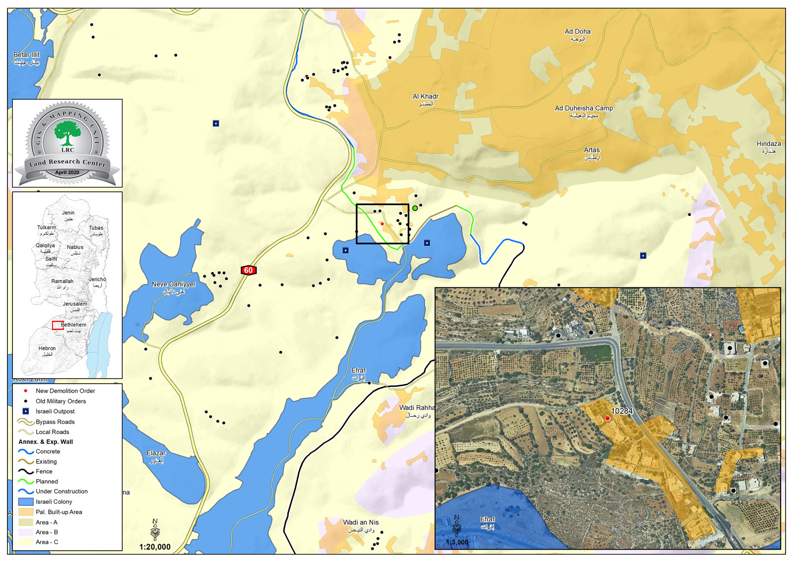
Location: Umm Ar-Rukba – Al-Khader town / Bethlehem governorate.
Date : April 22nd 2020.
Perpetrator: The Israeli Occupation Civil Administration.
Victims: Mohammed Da’ado’a.
Description:
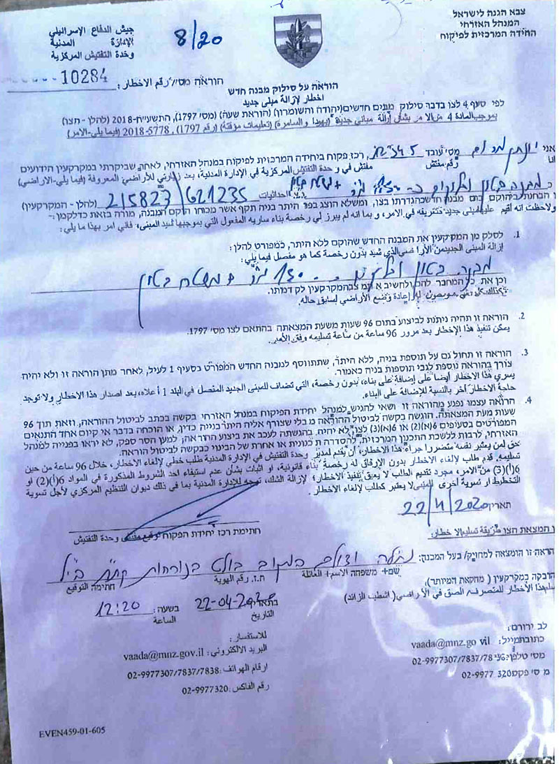
A vehicle from the Israeli Occupation civil administration protected by the occupation forces raided Umm Ar-Rukba area in April 22nd 2020, and notified citizen Mahmoud Da’do’u to remove his agricultural structure within 96 hours, on the pretext of building without licenses.
The notice ordered removing the structure within 96 hours , and in case the owner breached the deadline, the civil administration will implement the operation.
Citizen Mahran Da’ado’a (The owner’s son) told LRC:
“During April, the Israeli Occupation authorities raided our house three times and took pictures of it and its surrounding including an agricultural facility we had for poultry breeding , and the last time they showed up they gave me a removal order within 96 hours , we contacted a lawyer to take the necessary measurements.”
Iyad Issa from Al-Khader municipality told LRC :
“The Occupation targeted Al-Khader municipality with three military orders , all of them were 96 hours removal notices , and we can’t do anything to protect the targeted facilities during the corona lockdown , as all of the human rights institutions and public directorates are closed.”
A notice to remove a building
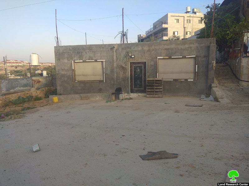
The targeted agricultural structure
The targeted facility is used in poultry breeding , and has a total area of 80 m2, and located in Mohammed Yacoub’s personal property.
The occupation and its settlers escalated their assaults against Palestinians in Al-Khader such as cutting trees and notifying buildings, Umm Ar-Rukba area is also a hot spot for the occupation forces attacks.
Israel devoured vast areas of Al-Khader lands for illegal settlement expansion , and during the recent years , expansion of illegal settlement didn’t stop, and land grabs continue , as the occupation authorities are working together with settlers to implement their project “The greater Jerusalem”.
About Al-Khader village:[1]
Al-Khader village is located 4 km from the western side of Bethlehem, it is bordered by Beit Jala and Batir from the north, Hussan and Nahaleen villages from the west, Aldoha, Wadi Rahhal, Beit Jala villages from the east, and Wadi Al-Nees from the south. Its population is 11960 people in 2017. Its gross area is 8,279 donums; 184 of them are the construction area.
The Israeli colonies have despoils 29 donums from the village's lands; two are colonies existed upon a part of the lands. The first one " Efrat" was constructed in 1979 A.D; they have usurped 5.8 donums, and its population 7037 colonists. The second one " Nafy Danial" eas constructed on 1982A.D; they have usurped 23 donums, and its population is 1073 colonists. A part of which is established upon the village's lands.
The bypass roads number 60 and 375 also despoiled more than 487 donums. In addition to establishing the apartheid upon its lands which causes the demolishing of 280 donums and isolating of 5638 donums behind it. The length of this apartheid existing upon the village's land is 2,805 meters.
The village's lands are classified in accordance with Oslo concord into areas( A,B ,C). Area A composes 10% , Area B 6%, Area C is the greatest area and it is under the total occupation domination, and it composes 84% from the total area. The areas are clarified in donums as following:
Area A (808) donums
AreaB (475) donums
Area C(6,996) donums
[1] GIS_LRC

This report was created with the financial support of the EU
The contents of this document are the sole responsibility of LRC , and do not in any way reflect the positions of the European Union