
Related
The occupation municipality forces Mustafa's family to self-demolish their home in the town of Al-Isawiya / occupied Jerusalem
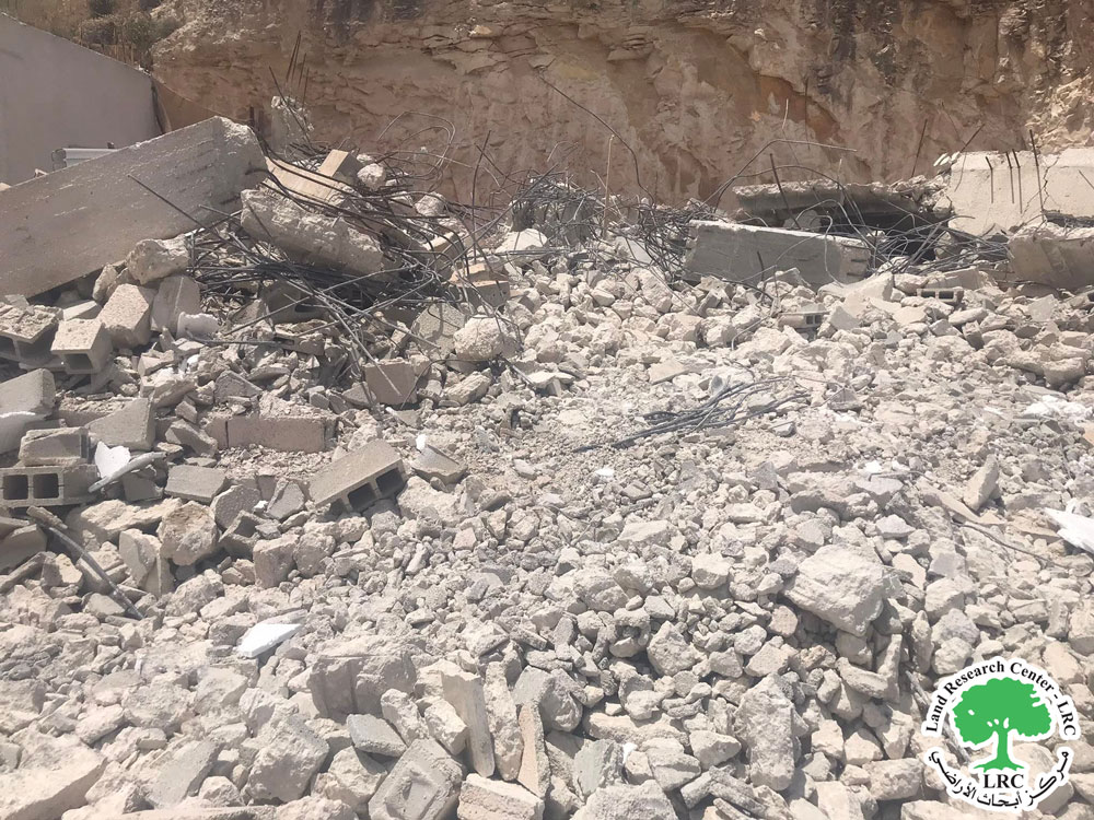
Mohammed Ali Mustafa, a resident of Al-Isawiya, Zafarana neighborhood, was forced to self-demolish his house on Saturday evening, the fifteenth of May 2022, by orders from the occupation municipality, which gave him only two days and warned him if not to implement, the municipality would demolish and fine him if he did not comply.
It is noteworthy that the owner put all his money to buy the plot of land in partnership with one of his friends, and then in 2019 he built a one-floor apartment with an area of 100 square meters, consisting of 3 rooms, two bathrooms, a salon and a kitchen, in order to accommodate him and his family of 7 members, 5 children and two girls. The construction cost him a lot of money, which he preferred not to mention because of his current condition and his grief over what had gone in the blink of an eye. The house was for him, as he said (I got tired of building and the house was my soul and my dream, but it disappeared) and (I delegated my command to God), and after the demolition the family dispersed and moved temporarily in the house of the owner’s father.
|
|
|
|
|
|


Al-Isawiya village is located to the northeast of the city of Jerusalem, and it is considered as a large prison due to the presence of a large concentration of settlements around it. On the southern and western side, the Hebrew University and Hadassah Hospital sit on its land, while on the eastern and northern side, there are many winding roads, and the wall separates it from the natural extension of its surroundings, such as the town of al-Zaim and the eastern and northern regions of the town.
Al-Isawiya town[1]:
The town of Al-Isawiya is located 7 km north of the city of Jerusalem. It is bordered to the north by Shuafat and Anata, to the west by Jerusalem and Shuafat, to the east by Al-Eizariya, to the south by Jerusalem and Al-Za’im.
It consists of a mountainous and foothills lands, surrounded by settlement projects on all sides, the Hebrew University and its facilities and residences on the southeast, and Hadassah Hospital and its facilities and residences on the western side, in addition to the confiscation of large areas of the village’s land, and the presence of the separation wall on its lands from the eastern and northern sides, which It separated it from its natural Palestinian surroundings, and it is worth noting that demolitions are repeated almost daily in the village, in the inhabited neighborhoods and on marginal lands alike.
Its total area is 9,419 dunums, of which 637 dunams are the building area of the village.
The occupation confiscated an area of (2305) dunams of its lands, as follows:
Settlement name
|
Establishing year
|
Size of land confiscated in dunams
|
Number of settlers
|
The Hebrew University - Har Hatzofim
|
1968
|
538.6
|
NA
|
French Hill - Givat Shapira
|
1968
|
234.3
|
6,631
|
Mishor Adumim
|
1974
|
246
|
NA
|
- The colonies looted from the village lands an area of (1019) dunams, which are:
2 - Bypass roads looted (641.5) dunums for the Roads No. 1 and (437).
- 3- the separation wall looted 44 dunums, and its length was 443 meters.
- 4- The occupation army camps looted (600) dunams
[1] Source: GIS Unit - Land Research Center.