
Related
Israel reveals a new scheme that targets Palestinian lands in Husan and Wad Foukin / Bethlehem governorate
Violation: Israel plans to lay their hands over more Palestinian lands for colonial expansion.
Location: Husan and Wad Foukin village / Bethlehem governorate.
Date: February 10th 2020.
Perpetrator: The Israeli Occupation Civil Administration – Colonization subcommittee.
Victims: People of Husan and Wad Foukin villages.
Description:
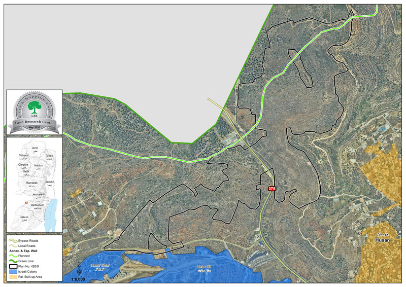
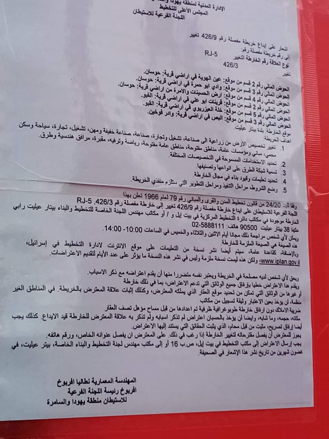
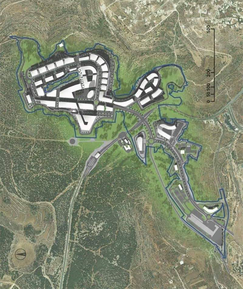
The Occupation’s so called Colonization subcommittee revealed detailed outline 462/9 , which shows in details the targeted lands in a new colonial scheme. The scheme will be implemented after changing lands’ allocations from agricultural to an area for industries, tourism, residence , entertainment and roads for the expansion of “Beitar Illit” on Ar-Reef Al-Gharbi lands – Bethlehem governorate.
Noteworthy, early 2020 the Israeli occupation is conducting a vicious attack that targets Palestinian lands, this is shown in confiscating vast areas of Agricultural Lands for colonial expansion, and issuing a handful of demolition orders, the occupation’s intention is to take over about 680 dunums in the area.
In the same context, The Prime minister of Israel Benjamin Netanyahu is imposing polices that facilitate violating Palestinian rights to Land and Housing, this urges extremist settlers to pursue voting for him and his radical rightist government. A good prime minister according to Israeli illegal settlers, is one who makes policies that facilitate land grabs and violations against Palestinians.
Husan Village council head Rami Hamamra told LRC:
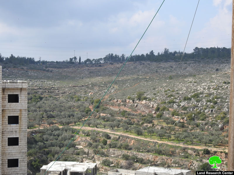
“This plan will eat up vast areas of olive groves, most of them are close to the main road.”
Noteworthy, The Israeli Occupation’s intention is to impose lockdown and separation on Palestinian territories in the West Bank, All these measurements are a clear violation of international law and the United Nations resolutions related to the protection of civilians under occupation.
|
|
|


The targeted area
|
|
The confiscation resolution
About Husan:[1]
Husan is 10 km west of Bethlehem and is edged with Wadi Fukin (west) Nahhalin (south), Wadi Rahall (east), and Battir (north).
It has a total area of 7360 dunums, 801 of which are built-up area. The Israeli occupation confiscated 2759 dunums to build Betar Illit and Hadar Betar colonies. Besides, bypass number '375 devoured 180 dunums.
The Apartheid Wall destroyed 124 dunums of Husan lands and isolated 150 dunums.
According to Oslo Accords, 14% of Husan is under Area B (PA is in charge of civil matters with Israel responsible for security). However, most of the village lands (86%) is under Area C (Israel maintains full security and administrative control). Here are the area in dunums:
Area B (1036) dunums
Area C (6324) dunums
[1] GIS-LRC

The contents of this document is the sole responsibility of LRC and can under no circumstances be regarded as reflecting the position of the European Union