
Related
Notice of Eviction for 1.4 dunums – Al-Khader / Bethlehem governorate
Violation: Notice of Eviction.
Location: Khallet Al-Fahm – Al-Khader town / Bethlehem governorate.
Date: June 18th 2020.
Perpetrators: The Israeli Occupation Civil Administration.
Victims: Citizen Mohammed Da’dou’.
Description:
Thursday, June 18th 2020 , the Israeli Occupation authorities raided Al-Khader town west Bethlehem , and served an eviction notice for a plot with a total area of (1.4) dunums that belong to citizen Mohammed Da’dou’.
Abu Samra told LRC the following:
“When I visited the plot I found an eviction notice, knowing that I visit it regularly and take care of it , the land contains grapes aging more than 3 years , considered as a main source of income for my family, especially after the economical crisis resulting from the Corona lockdown , which is used by the Israeli forces and colonists to escalate violations against Palestinians.”
Abu Samra asserted: “We will continue work on our land, the Occupation’s notice won’t stop us from cultivating it. I am forced to go to the occupation court to defend my right in front of the Offender, because it is my only hope.”
The Occupation Authorities ordered the eviction and return of the plot to its previous status within 45 day , and threatened in case the owner failed to carry out the eviction , the occupation authorities will evict the plot and make him pay all the costs.
Palestinians do not believe in Israeli Juridical systems, but still files objections to the Israeli Occupation’s court .
The following table shows more information about the targeted family:
| owner | No.family members | children | Notice no |
| Mohammed Da’dou’ | 6 | 4 | 001155 |
|
|
|
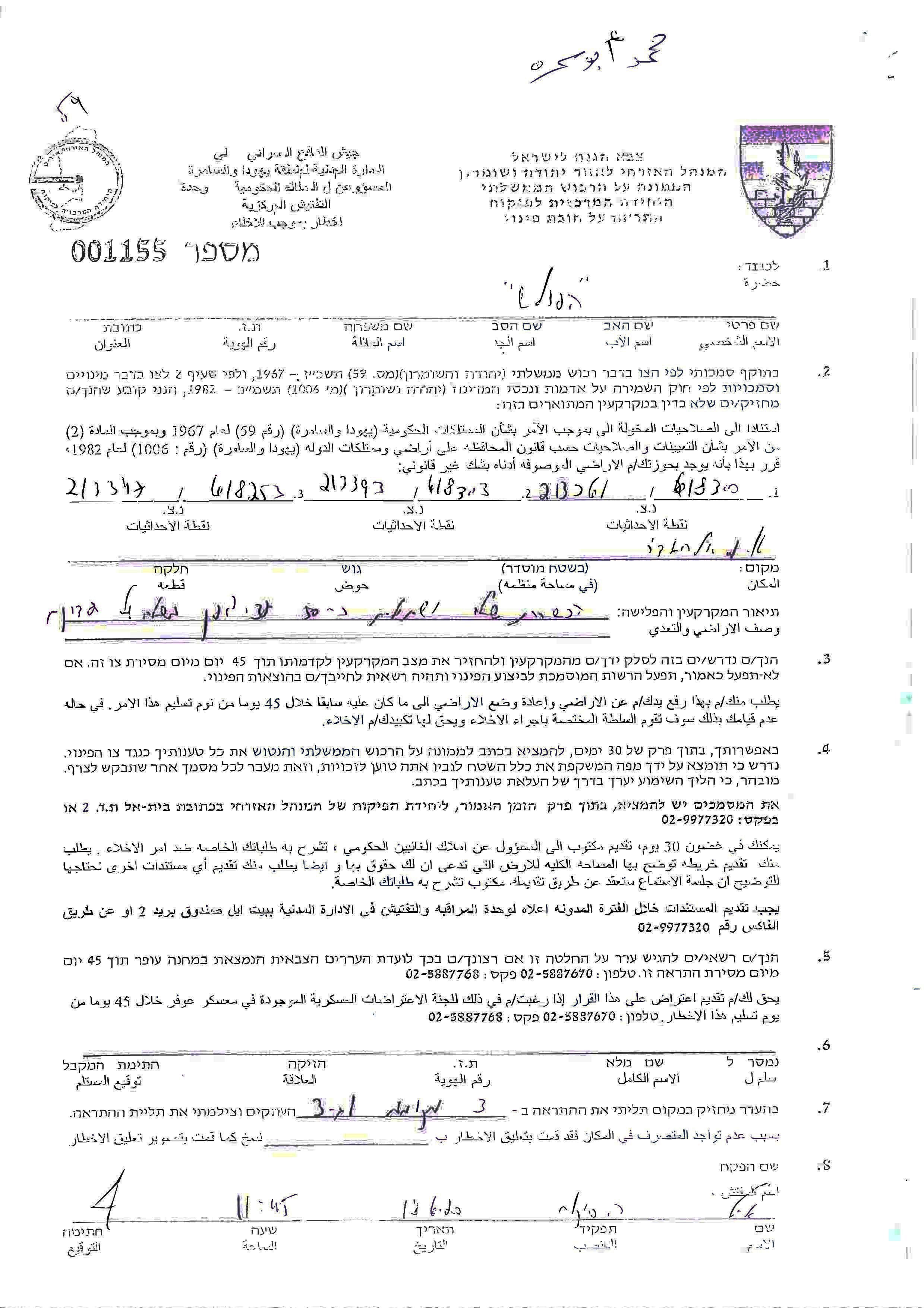
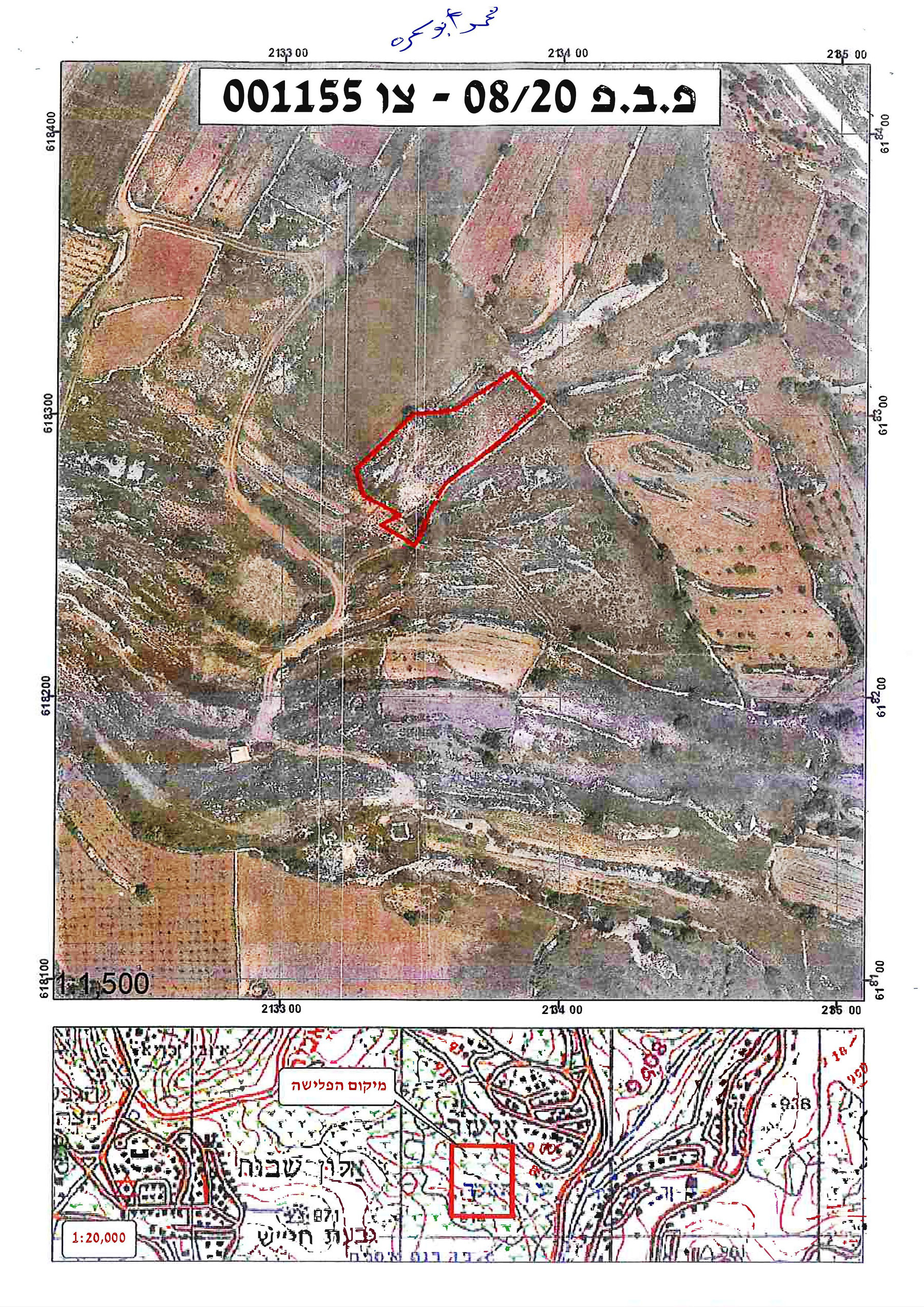
Photos 1+2: Eviction notice an attached map

Aerial photo showing the location of the plot
“Elazar” colony is built on Al-Khader land, where the occupation is attempting to take over vast areas of lands to expand their illegal colonies, despite the UN resolutions that considered Israeli colonies illegal , and that colonial activities in the West Bank is a serious violation of Human rights. In addition, Human Rights Council 41st session for 2019, pointed out that the West Bank have been turned into isolated geographical units, which hinders access to Natural Resources. However, the Israeli Occupation ignores international community, and only seeks to take over more Palestinian lands and Natural Resources.
During 2020 , the world experienced a lockdown due to the spread of a pandemic , many expressed how hard the experience was , without knowing that Palestinians are deprived from their movement right every day for years.
Noteworthy, Eviction means uprooting trees and plants , demolishing retaining walls and any other structures ..etc, usually ordered for lands classified as state properties in the Israeli Occupation’s records, noting that Palestinians do have ownership deeds for those lands , but the Occupation completely ignores that fact.
About Al-Khader village:[1]
Al-Khader village is located 4 km from the western side of Bethlehem, it is bordered by Beit Jala and Batir from the north, Hussan and Nahaleen villages from the west, Aldoha, Wadi Rahhal, Beit Jala villages from the east, and Wadi Al-Nees from the south. Its population is 11960 people in 2017. Its gross area is 8,279 donums; 184 of them are the construction area.
The Israeli colonies have despoils 29 donums from the village's lands; two are colonies existed upon a part of the lands. The first one " Efrat" was constructed in 1979 A.D; they have usurped 5.8 donums, and its population 7037 colonists. The second one " Nafy Danial" eas constructed on 1982A.D; they have usurped 23 donums, and its population is 1073 colonists. A part of which is established upon the village's lands.
The bypass roads number 60 and 375 also despoiled more than 487 donums. In addition to establishing the apartheid upon its lands which causes the demolishing of 280 donums and isolating of 5638 donums behind it. The length of this apartheid existing upon the village's land is 2,805 meters.
The village's lands are classified in accordance with Oslo concord into areas( A,B ,C). Area A composes 10% , Area B 6%, Area C is the greatest area and it is under the total occupation domination, and it composes 84% from the total area. The areas are clarified in donums as following:
- Area A (808) donums.
- AreaB (475) donums.
- Area C(6,996) donums.
[1] GIS-LRC

This report was prepared with EU funding, the contents of this document do not reflect positions of the European Union