2019-05-06
Settlers of Yitzhar open a road in Madama / Nablus
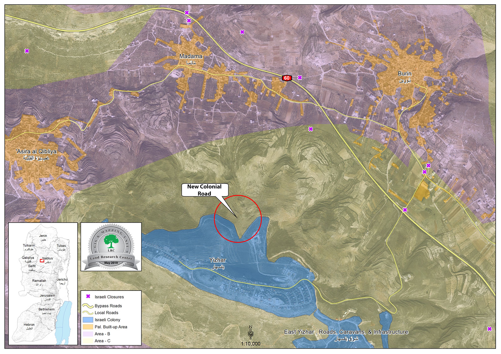
Violation : opening a colonial road.
Location: Madama village / south Nablus.
Date: 6/05/2019.
Perpetrator: Settlers of Yitzhar.
Victims : number of farmers from the village.
Description:
Monday, 6th of May 2019 , expansion works around Yitzhar settlement were seen on the expenses of Madama village lands in a location known as Al-Qa’adat.
Madama village council head told LRC reporter:
“Monday , 6th of may 2019 , bulldozers operated by “Yitzhar” settlers was seen ravaging lands in Al-Qa’adat area. Number of the village council settlers were observing the ravaging since it started at 7:00 , and called the Palestinian Liaison office to inform them about the new updates at the location.”
After five hours , the ravaging stopped and settlers withdrew , after pressures from Palestinian farmers who demonstrated at the location.
Nassar said that the ravaged road is 700 m long * 6 m wide, it occurred on plots belong to Mohammad Nassar, Naem Nassar, Nasseer Nassar, Ibrahim Nassar and Bassam Nassar.
The towns farmers are worried that after opening the road , the occupation authorities will prohibit them from accessing their lands under security claims, which will isolate 140 dunums.
Madama:[1]
Madama is 12km to the southeast of Nablus and is surrounded by Iraq Burin and Till (north), Asira al Qibliya (west), Burin (east), and Urif (south).
According to 2017 population projections , Madama is inhabited by 2,092 people.
It has a total area of 3824 dunums, 190 of which are built-up area of the village.
The Israeli occupation confiscated 118 dunums for Yitzhar colony which was built on Madama lands in 1983. The colony is inhabited by 400 colonists.
The Israeli occupation is not only taking over land and water resources of the village, but they are also targeting Palestinians residing there through attacking them on almost a daily basis.
Yitzhar:
The colony of Yitzhar was established in 1983 on Palestinian lands belonging to the villages of Burin and Asira Al Qiblia south west of the city of Nablus. The colony has expanded multiple times ever since as additional tens of dunums were confiscated for that purpose. The additional dunums were taken from the villages of Burin, Asira Al Qiblia, Oreef, Madama and Huwwara. The built-up area of the colony was 158 dunums as of 2005 while the area of land under its jurisdiction is about 1,800 dunums located in Parcel .
[1] GIS-LRC

This document has been produced with the financial assistance of the European Union The content of this document is the sole responsibility of LRC and can under no circumstances be regarded as reflecting the position of the European Union