2024-07-01
Occupation Forces Demolish Well and Retaining Walls in Kharbatha al-Misbah Village/ Ramallah Governorate
- Violation: Demolition of a well and retaining walls.
- Location: Kharbatha al-Misbah Village / Ramallah Governorate.
- Date of Violation: July 1, 2024.
- Perpetrator: The so-called Israeli Civil Administration.
- Affected Party: Farmer Abdullah Ahmad Darraj.
Description:
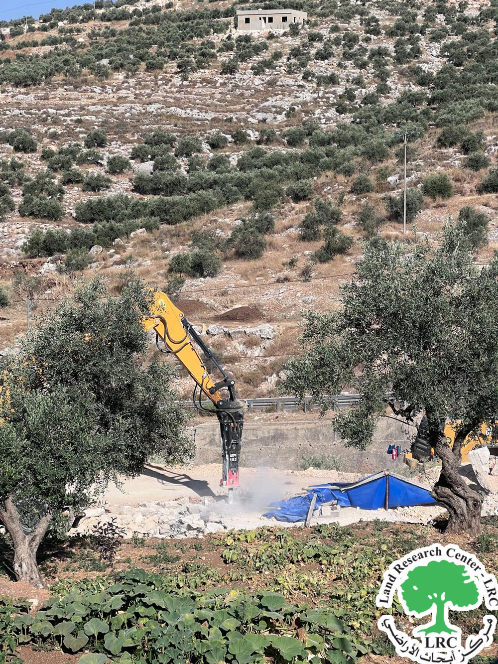
On Monday, July 1, 2024, at noon, Israeli occupation forces stormed Kharbatha al-Misbah Village, located west of Ramallah city. They demolished a water well situated in the eastern part of the village and also destroyed retaining walls surrounding a two-dunum agricultural plot.
The affected land belongs to farmer Abdullah Ahmad Darraj, who supports a family of eight members, including four females and four children.
It is worth noting that the targeted structures were previously notified on June 11, 2023. At that time, the affected farmer opened a legal file and hired a lawyer to follow up, but the occupation authorities rejected the file and proceeded with the demolition.
|
|
|
|
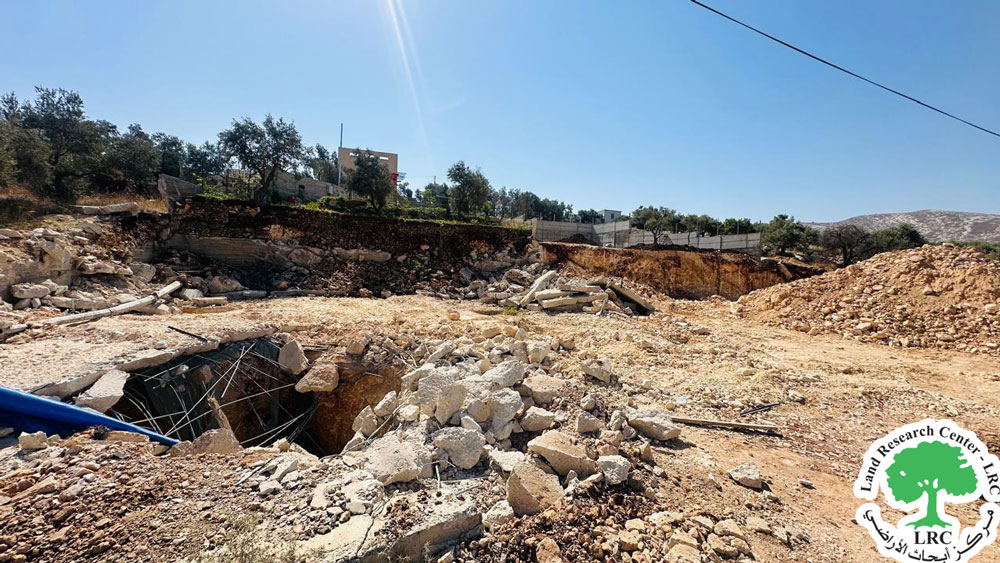

Evidence of the demolished well and walls
According to field monitoring, the damage included:
- Destruction of an agricultural well with a capacity of 45 cubic meters, intended for irrigating approximately two dunums of olive trees. The well was in the construction phase.
- Destruction of retaining walls made of concrete, five meters high and 23 meters long, which surrounded the plot of land.
The affected farmer reported to the Land Research Center researcher: "I own an agricultural plot that I recently developed. I built retaining walls around it and started constructing a rainwater collection well. The land was planted with various olive saplings and seven fig saplings. I had previously received a notice including orders to stop work and construction, and I had prepared everything and opened a legal file at the Jerusalem Center for Field Follow-up. However, I was shocked by the demolition, which destroyed the infrastructure of my land, leaving me with nothing. The estimated losses amount to about 189,000 shekels."
Targeting Agricultural Lands and Demolishing Wells:
Targeting agricultural lands and demolishing wells is a blatant violation of Palestinian environmental rights. When the occupation demolishes retaining walls, it leads to soil erosion and deterioration, destroying vegetation and increasing desertification, which negatively impacts green areas and agricultural land. According to field research by the Land Research Center, during the first half of 2024, 17 walls or stone terraces totaling 3,250 meters, protecting over 25 dunums, were documented as having been demolished.
Targeting wells, water tanks, and ponds also increases drought and desertification in agricultural lands, leading to complete destruction. The occupation’s policy of preventing and destroying wells is systematic, followed by the occupation army and settlers, who also target water springs, polluting or controlling them, as seen with Ein al-Sakut in the Jordan Valley and Ein Helwa, among others.
According to the Land Research Center’s field team, during the first half of 2024, the occupation army demolished 32 wells, water tanks, and artesian wells with a capacity of 463 cubic meters, and destroyed water lines totaling 1,400 meters. These wells irrigated 550 dunums of agricultural land, resulting in the destruction of crops due to the loss of irrigation sources.
Settlers’ attacks on Palestinian water resources have intensified. The Land Research Center reports that settlers have destroyed or polluted/looted 10 water wells, 66 water tanks, 8 water cisterns, and confiscated 10 water pumps, 6 water networks totaling 770 meters, and 7 water springs.
Kharbatha al-Misbah Village[1]:
Kharbatha al-Misbah Village is located southwest of Ramallah city, approximately 15 kilometers from the city center. It is bordered to the east by the lands of Beit 'Ur al-Foqa, to the west by Beit Sira, to the north by Beit 'Ur al-Tahta, and to the south by Beit Liqya. The village is situated around 450 meters above sea level and is one of the border villages, being just 2 kilometers from the Green Line.
Population: According to 2013 statistics, Kharbatha al-Misbah has approximately 7,000 residents distributed among four main families:
- Family (al-Habl): 33% of the population.
- Family (Darraj): 25% of the population.
- Family (Harboush): 22% of the population.
- Family (Muslih): 15% of the population.
- **Plus 5% of refugees residing in the village since 1967.
[1] LRC-GIS.
مشروع: حماية الحقوق البيئية الفلسطينية في مناطق "ج" SPERAC IV - FCDO
Disclaimer: The views and opinions expressed in this report are those of Land Research Center and do not necessarily reflect the views or positions of the project donor; the Norwegian Refugee Council.
إخلاء المسؤولية: الآراء ووجهات النظر الواردة في هذا التقرير هي آراء ووجهات نظر مركز أبحاث الأراضي ولا تعكس بالضرورة وجهات نظر أو مواقف الجهة المانحة للمشروع؛ المجلس النرويجي. للاجئين