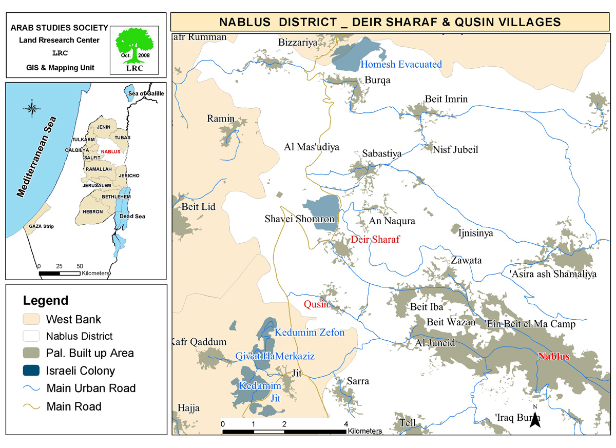
The occupation demolishes a water well and factory foundations in the Deir Sharaf area/ Nablus Governorate
Violation: Demolition of a water collection well and factory foundations.
Location: Deir Sharaf village / Nablus Governorate.
Date of violation: 21/07/2024.
Perpetrating entity: The so-called Israeli Civil Administration.
Affected party: Al-Tal Al-Akhdar Company “ Mr. Hashim Ahmad Mohsen”.
Description:
On Sunday, July 21, 2024, at noon, the Israeli occupation forces raided the "Al-Zahura" area, located northwest of Deir Sharaf village in Nablus Governorate.
It is worth mentioning that the Israeli army, in coordination with the so-called construction and planning inspector from the Israeli Civil Administration, began executing a demolition operation targeting a rainwater collection well with a capacity of 90 cubic meters, as well as the foundations of a factory covering an area of 800 square meters. The demolition was carried out under the pretext of unlicensed construction.
The water collection well and the factory foundations belong to Al-Tal Al-Akhdar Company, represented by Mr. Hashim Mohsen.
It is also mentioned that the occupation had previously issued an order to stop work and construction at the factory in early July 2023. The company’s lawyer filed a request for a permit and opened a legal file to appeal the occupation’s notice. However, despite completing the permit request file, the occupation rejected it and insisted on demolishing the entire facility, with the aim of preventing the use of lands within the "C" areas of the Oslo Agreement, leaving them empty and as colonial reserves.
Introduction to Deir Sharaf Village:
Deir Sharaf village is located 7 km northwest of Ramallah. It is bordered to the north by the villages of Burqa and Ramin, to the west by the village of Beit Lid, to the east by the villages of An-Nakoura and Sebastia, and to the south by the villages of Qusin and Kafr Qaddum.
The population of the village is 2,949 people as of 2017. The total area of the village is 7,745 dunams, of which 403 dunams are designated as the built-up area of the village.
Israeli settlements have seized 265 dunams of the village's land. Part of the village's land is occupied by the "Shafei Shomron" settlement, which was established in 1977 and has confiscated 265 dunams of village land, housing 604 settlers.
Additionally, the bypass roads No. 60 and No. 557 have confiscated more than 823 dunams of land.
According to the Oslo Agreement, the village's land is classified into Areas B and C. Area B makes up 20% of the land, while the larger portion, Area C, is under full Israeli control and constitutes 80% of the total land area. The areas are as follows:
- Area B: 1,540 dunams
- Area C: 6,206 dunams
[1] Source: GIS Unit – Land Research Center.
مشروع: حماية الحقوق البيئية الفلسطينية في مناطق "ج" SPERAC IV - GFFO
Disclaimer: The views and opinions expressed in this report are those of Land Research Center and do not necessarily reflect the views or positions of the project donor; the Norwegian Refugee Council.
إخلاء المسؤولية: الآراء ووجهات النظر الواردة في هذا التقرير هي آراء ووجهات نظر مركز أبحاث الأراضي ولا تعكس بالضرورة وجهات نظر أو مواقف الجهة المانحة للمشروع؛ المجلس النرويجي. للاجئين

