2018-11-21
The occupation issues a military order on an Agricultural room in Al-Khader / Bethlehem governorate
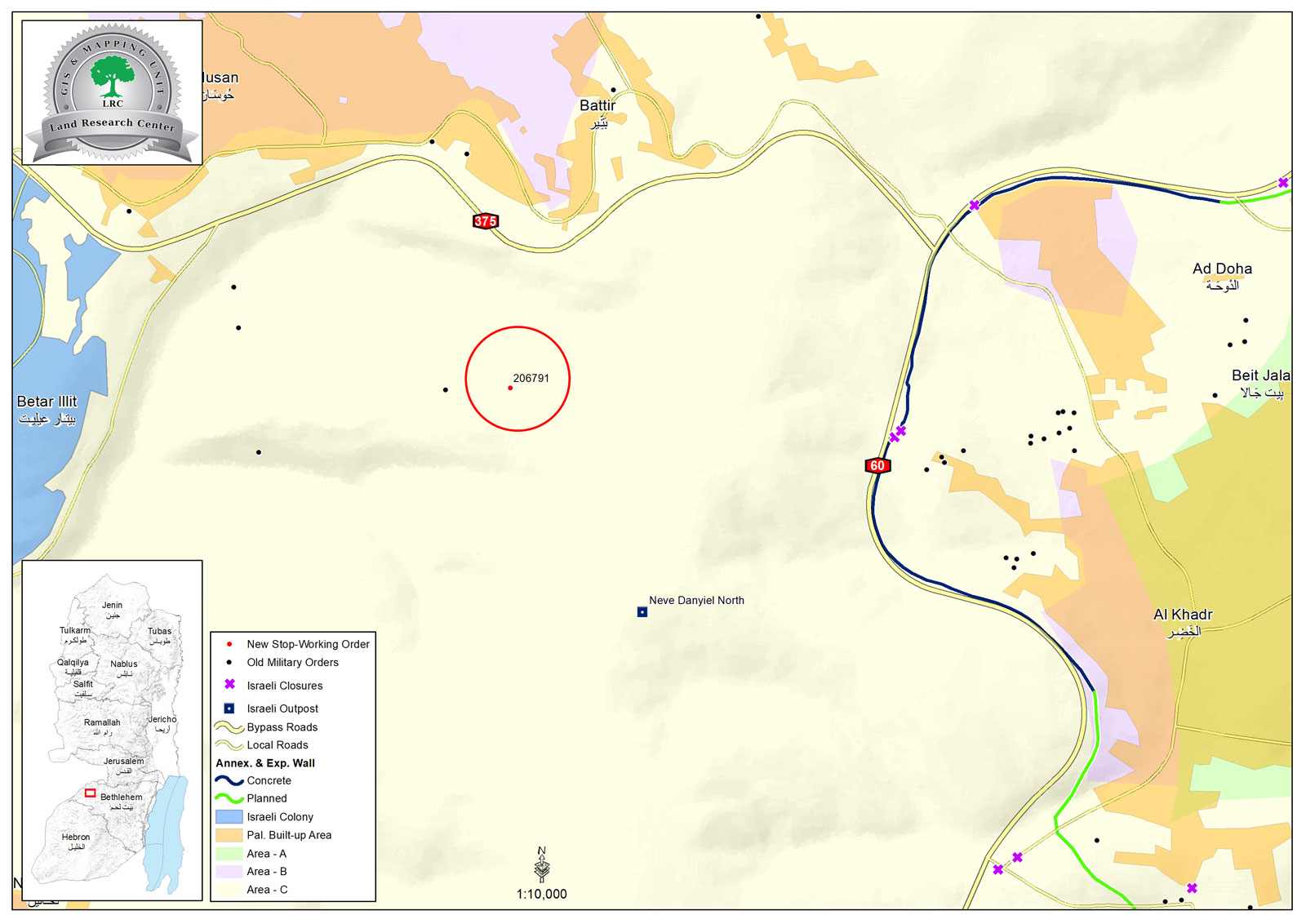
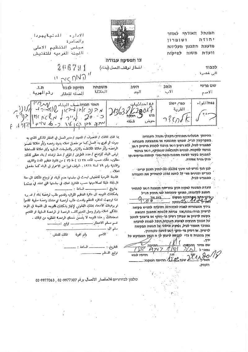
Violation : The occupation serves a stop-work order on an agricultural room.
Location: Wad Abu Hassan- Al-Khader / Bethlehem governorate.
Date: 21/11/2018.
Perpetrator: The Israeli occupation civil administration.
Victims: Mustafa Salah.
Description:
The Israeli occupation army and civil administration raided Wad Abu Hassan in Al-Khader , and served a military order to an agricultural room and an outer bathroom that belong to Mustafa Salah on the pretext of building before getting proper licenses.
Iyad Sbaih from Milad office told LRC reporter:
“A farmer found the military order thrown in the ground, and took it to our office in Al-Khader municipality, we immediately called the owner , in order to file a plea.
Ahmad whose family owns the land, built a room in the plot in order to use it in agricultural seasons, but the occupation rapidly notified it”
Reportedly, The plot is about 1 kilometer from the main street, owners need about 30 minutes to reach their land, but that does not prevent them from daily visits to rehabilitate and take care of their lands.
According to the military order , the 5th of November will be the date of the subcommittee session in “Beit El” military court to decide the fate of the structures.
a military order targeting an agricultural room and an outdoor bathroom
The following table shows more information about the targeted family:
name | Family members | Children | structures | Military order number |
Mustafa Salah | 9 | 5 | Agricultural room and an outdoor bathroom | 266791 |
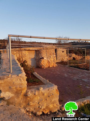
The targeted agricultural room
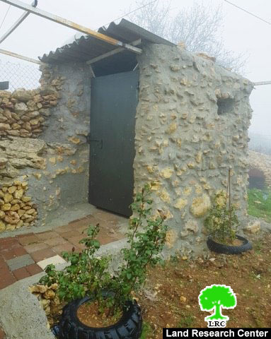
the targeted outdoor bathroom
About Al-Khader village:[1]
Al-Khader village is located 4 km from the western side of Bethlehem, it is bordered by Beit Jala and Batir from the north, Hussan and Nahaleen villages from the west, Aldoha, Wadi Rahhal, Beit Jala villages from the east, and Wadi Al-Nees from the south. Its population is 9774 people in 2007. Its gross area is 8,279 donums; 184 of them are the construction area.
The Israeli colonies have despoils 29 donums from the village's lands; two are colonies existed upon a part of the lands. The first one " Efrat" was constructed in 1979 A.D; they have usurped 5.8 donums, and its population 7037 colonists. The second one " Nafy Danial" eas constructed on 1982A.D; they have usurped 23 donums, and its population is 1073 colonists. A part of which is established upon the village's lands.
The bypass roads number 60 and 375 also despoiled more than 487 donums. In addition to establishing the apartheid upon its lands which causes the demolishing of 280 donums and isolating of 5638 donums behind it. The length of this apartheid existing upon the village's land is 2,805 meters.
The village's lands are classified in accordance with Oslo concord into areas( A,B ,C). Area A composes 10% , Area B 6%, Area C is the greatest area and it is under the total occupation domination, and it composes 84% from the total area. The areas are clarified in donums as following:
Area A (808) donums.
AreaB (475) donums.
Area C(6,996) donums .
[1] GIS- LRC

The contents of this document is the sole responsibility of LRC and can under no circumstances be regarded as reflecting the position of the European Union