2019-07-30
The Occupation’s municipality laid their hands on a plot in Sur Baher / Occupied Jerusalem
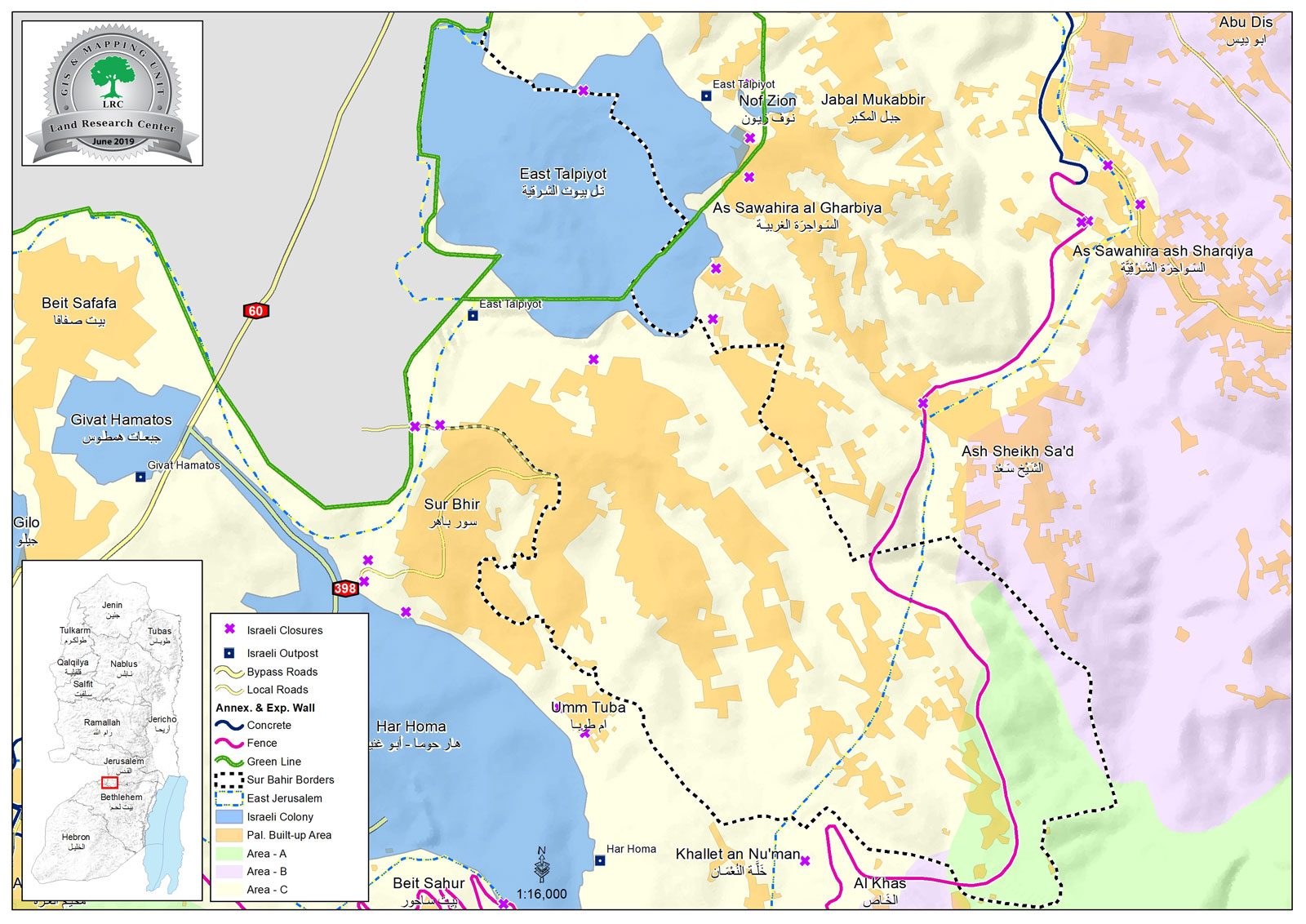
The occupation’s municipality laid their hands on a plot in Sur Baher south Occupied Jerusalem , for “Public services” as they claim. The occupation forces and municipality workers raided the plot Tuesday , 30 of July 2019 , and carried on works in an attempt to lay hands on it.
Hamada Hamada Spokesperson for Wadi Al-Humus neighborhood commission told LRC reporter: “The targeted plot has an area of 6.6 dunums, it belongs to citizens Omar Dabesh and Yassir Dwiyat , close to “Talpiot” settlement.”
Omar Dabesh told LRC reporter:
“The municipality claims that they will build a school or a kindergarten at the location . We tried that before, when the occupation’s municipality established a public center in the town , the center did not benefit us , on the contrary it brought us difficulties . Also, recently the occupation municipality declared that they will construct a building related to the Ministry of Interior, with an intention to provide facilities for Jerusalemites in Sur Bahir and Jabal Al-Mukabir , after they completed the construction , the building was transformed into a police station. Thus, the occupation’s claims of providing services are only misleading and fraud.”
Dabesh asserted:
“I told the occupation’s municipality that I donate my plot for the construction of a kindergarten for the town’s people , but they refused, which reflects their intention for using the land for different ends. And we all know that the occupation’s ultimate goal is to take over more and more lands of what is remained in Jerusalem.
Several lawyers have united efforts to stop the confiscation. While, the occupation’s municipality lawyer came to my house and told me to sign a waiver , in exchange for providing me and my sons with construction permits.”
Sur Baher village:[1]
3 km south Jerusalem city, Sur Baher is bordered by Al-Sawahira Al-Gharbiyya, Jabal Al-Mukabir and (Talpiot) settlement on confiscated lands (North), The Green Line and the occupied territories of 1948 , Ash-Shaikh Sa’ad village (east), and Beit Sahour ,Umm Tuba and Har Homa settlement (south).
Sur Baher and Um Tuba together have a population of 18,137 people in 2011 census “The Jerusalem Institute for Israeli studies 2012”.
The town’s population come from several families: Duyat, Dabesh, Nemr, Eleyan, Hamada, 'Amaira, Abu Kufur, Bukairat, Jbour, Jad Allah, Abu Jamid , Al Atrash.
Sur Baher has a total area of 6,894 dunums , of which 2,076 dunums are the town’s built up area, it is in the borders of the occupation’s municipality in Jerusalem, after they illegally annexed it in 1967.
The occupation confiscated (1517) dunums from Sur Baher for the following purposes:
Talpiot settlement, which was established in 1973 devoured 1291 dunums , and inhabited by 12,591 people.
The segregation wall (2,260 m long) devoured 226 dunums, and blocked 6,033 dunums (west) and 861 dunums (east).
Oslo conventions divided the town as the following :
A area (764) dunums.
B area (134) dunums.
C area (5,995) dunums.
[1] GIS-LRC

