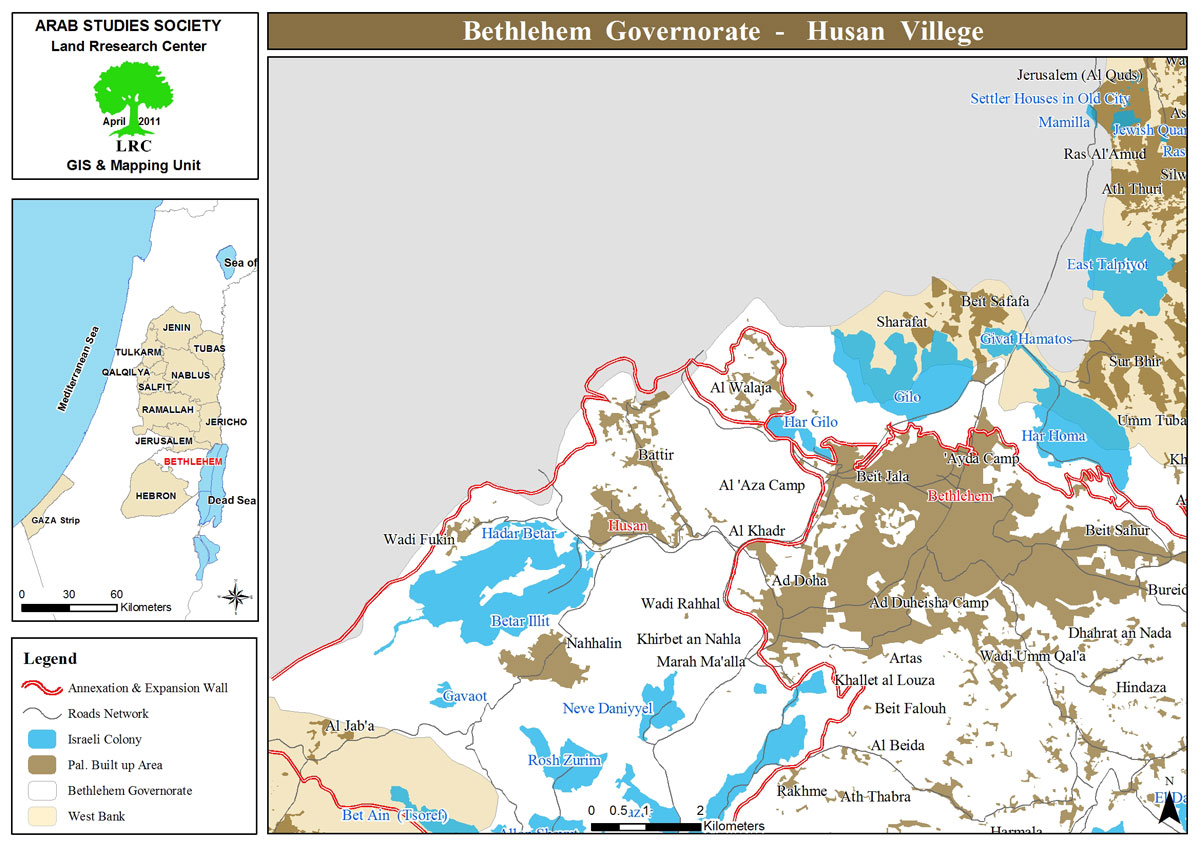
In order to open a Military Road, The Occupation Ravages lands in Husan village / Bethlehem Governorate
Violation: Clearing agricultural lands for the construction of a military road.
Location: Al-Sharafa - Husan village, Bethlehem Governorate.
Date of Violation: April 16, 2024.
Perpetrator: Israeli Occupation Army.
Affected Party: Residents of Husan village.
Description:
On Tuesday, April 16, 2024, bulldozers belonging to the Israeli Occupation Army cleared agricultural lands in the Al-Sharafa area, located at the eastern entrance on the main road in Husan village. The clearing was conducted to construct a military road for the use of Israeli army vehicles. The estimated area of the cleared lands is approximately 100 dunums, as of the date this report was prepared.
Rami Hamamra, the director of the village council in Husan, stated to the LRC researcher:
"Over the past and current periods, Israeli occupation aggressions on Husan village have persisted, targeting homes, residents, and agricultural lands. These acts aim to pressure residents and prevent them from accessing their farmlands. The construction of this road is meant to facilitate the movement of occupation vehicles at the expense of farmers' lands and to provide protection for settlers."
It is worth noting that, in the past, the Israeli army has cleared vast lands to expand the colonial road No. “60”.
Rami Hamamra added:
"The colonial road serves the occupation’s interests, the expansion of settlements, and the growth of outposts. This expansion is accelerating, all under the pretext of settler protection. The occupation aims to control vast areas and exploits the war period and the absence of international law enforcement to achieve its goals."
Azmi Hamamra, the deputy head of Husan’s council, also informed the LRC researcher:
"According to the Civil Administration, the occupation also plans to remove the 'iron fence' and rebuild it with stronger materials, adding cameras and lighting to enhance settler protection. Additionally, the occupation prohibits any citizen from accessing the western gate and shoots at anyone who approaches it."
Impacted residents have reported the violation to relevant human rights organizations, seeking necessary measures to halt the expansion and aggression against agricultural lands.
Overview of the Targeted Village of Husan[2]:
Husan village is located 10 kilometers west of Bethlehem city. It is bordered by Battir village to the north, Wadi Fukin to the west, Wadi Rahal to the east, and Nahalin to the south.
As of 2018, the population of Husan was 7,048. The village spans a total area of 7,360 dunums, of which 801 dunums constitute the built-up area.
Israeli settlements have seized 2,759 dunums of Husan’s lands. Two settlements occupy its lands:
Har Beitar, established in 1978, which confiscated 55.7 dunums.
Beitar Illit, established in 1985, which seized 2,703 dunums and houses 22,926 settlers.
In addition, Bypass Road No. 375 has expropriated over 361 dunums. Furthermore, the construction of the Israeli separation wall on Husan’s lands resulted in the destruction of 124 dunums along its route, while isolating 150 dunums behind it, denying owners access to cultivate or care for them. The wall extends for 1,244 meters through the village.
- The village's lands are classified according to the Oslo Accords into Areas (B and C), with Area B comprising only 14% of the village's total area, while Area C, which is under full Israeli control, constitutes 86%.
- Area B: (1,036 dunums).
- Area C: (6,324 dunums) .
Area C:
Following the signing of the Oslo Accords on September 13, 1993, in the United States between Israel and the Palestine Liberation Organization, the West Bank was divided into four categories (A, B, C, and nature reserves). Area C comprises 60.9% of the West Bank’s total area of 5,660 km² and contains significant resources vital for building a Palestinian state.
According to the Oslo Accords, Area C was supposed to gradually transition to Palestinian Authority control and eventually become part of the Palestinian state. However, this transition never occurred, leaving the area under Israeli administrative and security control.
Source: Geographic Information Systems Unit – LRC.
مشروع: حماية الحقوق البيئية الفلسطينية في مناطق "ج" SPERAC IV - FCDO
Disclaimer: The views and opinions expressed in this report are those of Land Research Center and do not necessarily reflect the views or positions of the project donor; the Norwegian Refugee Council.
إخلاء المسؤولية: الآراء ووجهات النظر الواردة في هذا التقرير هي آراء ووجهات نظر مركز أبحاث الأراضي ولا تعكس بالضرورة وجهات نظر أو مواقف الجهة المانحة للمشروع؛ المجلس النرويجي. للاجئين

