
2024-08-04
Expansion of a New Settlement Outpost on Land in Kafr Ad Dik West of Salfit
- Violation: Expansion of a new pastoral outpost.
- Location: Kafr Ad Dik Village / Salfit Governorate.
- Date of Violation: August 4, 2024.
- Perpetrators: Settlers.
- Victims: Residents of Kafr Ad Dik Village.
Description:
On Sunday, August 4, 2024, settlers began expanding the outpost named "Bnat Bor," which is established on land belonging to Kafr Ad Dik Village, west of Salfit Governorate. They had previously seized the land and established this outpost.
The settlers conducted work to create a colonial road approximately 1 km long and constructed three residential units on the slope of a hill west of the village, covering an area of about 2 dunams. This area overlooks extensive olive fields, extending over approximately 500 dunams. Additionally, this new outpost serves as a link to the "Boudeil" settlement, which is located on the village's land, and is only 200 meters away from that settlement.
Land leveling and expansion work at the colonial outpost
Mr. Ala’a Al-Deek, the head of Kafr Ad Dik Municipality, informed the field research team at the Land Research Center as follows:
"There is a real danger from this new outpost because it is located in an area overlooking the village's land, which has become the only open space for farmers and residents of the village. Furthermore, it is near an ancient Roman fortress that reflects the region’s history. It is not unlikely that the settlers will attempt to seize the entire area, especially the archaeological site. The presence of settlers at this location could lead to attacks on the olive fields and prevent farmers from harvesting their olives, paving the way for them to take control of the area. It is noteworthy that olive trees provide income for more than 60 families in the village."
The Bnat Bor area is considered a strategically important location for the village. Part of the village’s land is classified by the occupation authorities as state land, and efforts are underway to seize it in one way or another. The region witnessed the cutting of numerous olive trees last year by the so-called Government Property Guard.
About Kafr Ad Dik Village:
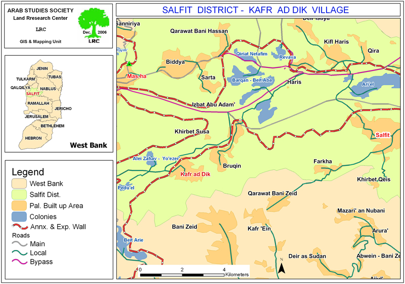
Kafr Ad Dik Village is located 15 km west of Salfit City. It is bordered to the north by Bidya, to the west by the villages of Rafat and Deir Ballut, to the east by the villages of Burqin and Sarta, and to the south by the village of Bani Zeid. As of 2017, the village had a population of 5,551. Its total area is 15,529 dunams, of which 791 dunams are designated for village construction.
The occupation has seized 2,477 dunams of its land, including:
- Settlements have taken 1,225 dunams from the village's land.
Name of Colony | Established year | Area of confiscated land / dunam | Colony Number |
Har Eli Zahaf | 1983 | 134 | NA |
Eli Zahaf – Yuezar | 1982 | 290 | 424 |
Baduneil | 1984 | 800 | 1088 |
Brokhein | 1999 | 1 | NA |
|
|
| |
Total |
| 1225 | 1512 |
- The bypass roads have seized 362 dunams.
- The Apartheid Wall has seized 890 dunams, and will isolate approximately 8,842 dunams behind it. The wall’s length on the village’s land is 8,905 meters.
According to the Oslo Accords, the lands of Kafr ad-Dik are classified as Area B, which constitutes 15% of the village’s area, while Area C, i.e. under full Israeli occupation control, constitutes 85%.
- Areas classified as “B” 2,252 dunums.
- Areas classified as “C” 13,277 dunums.
1 Source: GIS- LRC.
مشروع: حماية الحقوق البيئية الفلسطينية في مناطق "ج" SPERAC IV - GFFO
Disclaimer: The views and opinions expressed in this report are those of Land Research Center and do not necessarily reflect the views or positions of the project donor; the Norwegian Refugee Council.
إخلاء المسؤولية: الآراء ووجهات النظر الواردة في هذا التقرير هي آراء ووجهات نظر مركز أبحاث الأراضي ولا تعكس بالضرورة وجهات نظر أو مواقف الجهة المانحة للمشروع؛ المجلس النرويجي. للاجئين