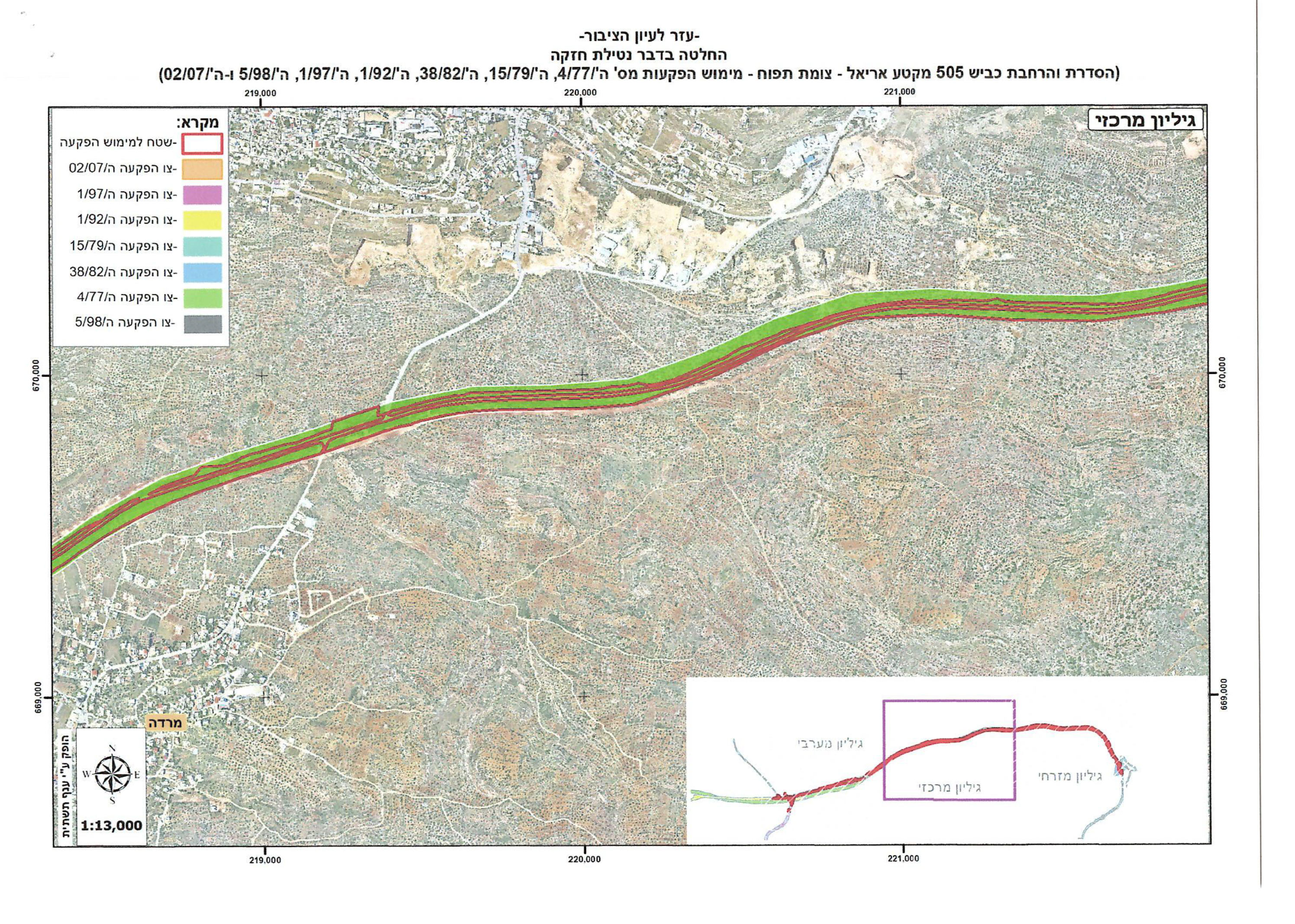
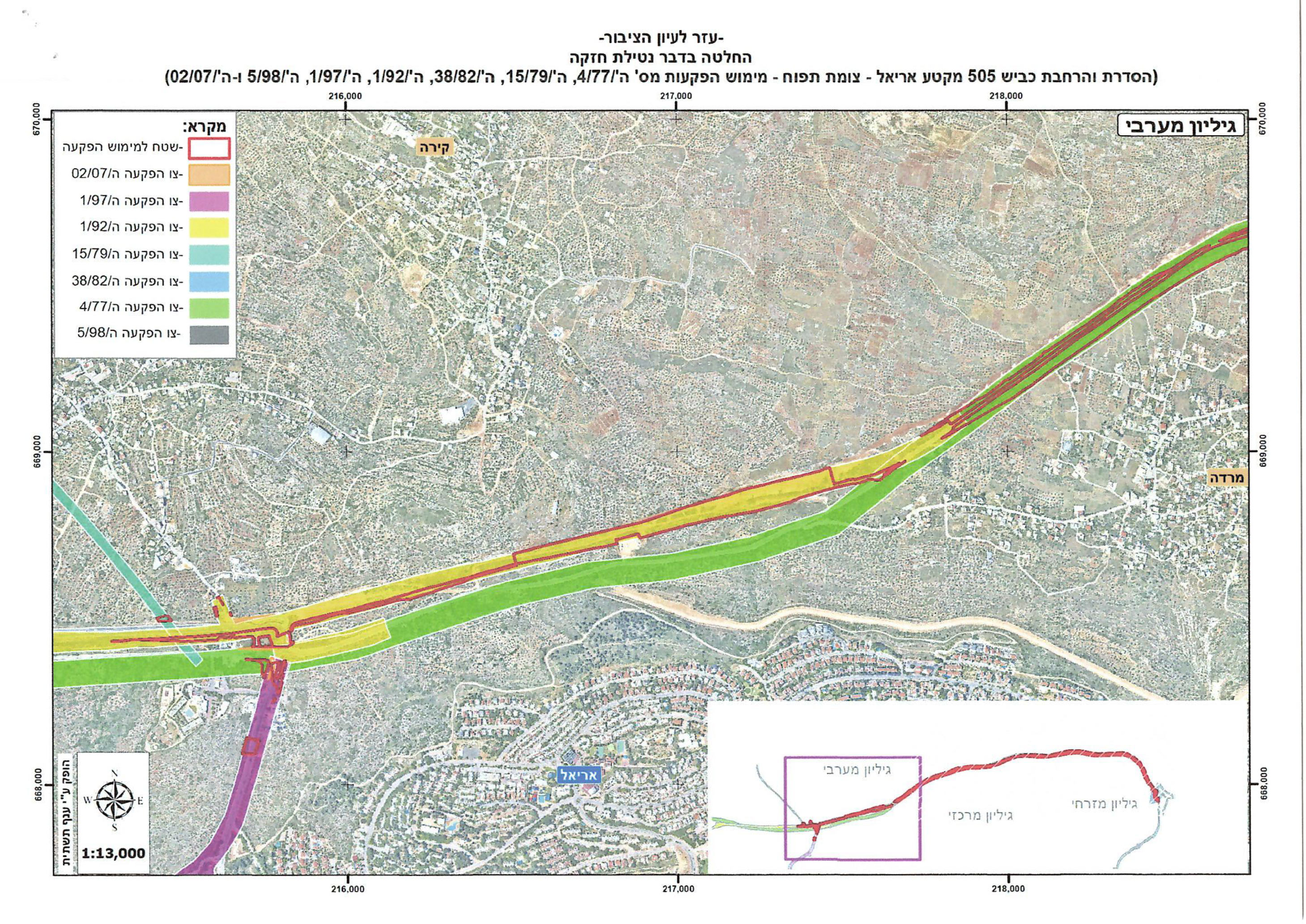
To expand a colonial road… A plan to confiscate 546 dunams of land from Nablus and Salfit governorates
Violation: Orders regarding the seizure of land-use rights.
Location: Nablus Governorate (Jama’in, Huwara) and Salfit Governorate (Kifl Haris, Marda, Yasuf).
Date of Plan Issuance: October 13, 2024.
Perpetrator: The so-called Israeli Civil Administration.
Affected Parties: A number of farmers and families in the area.
Description:
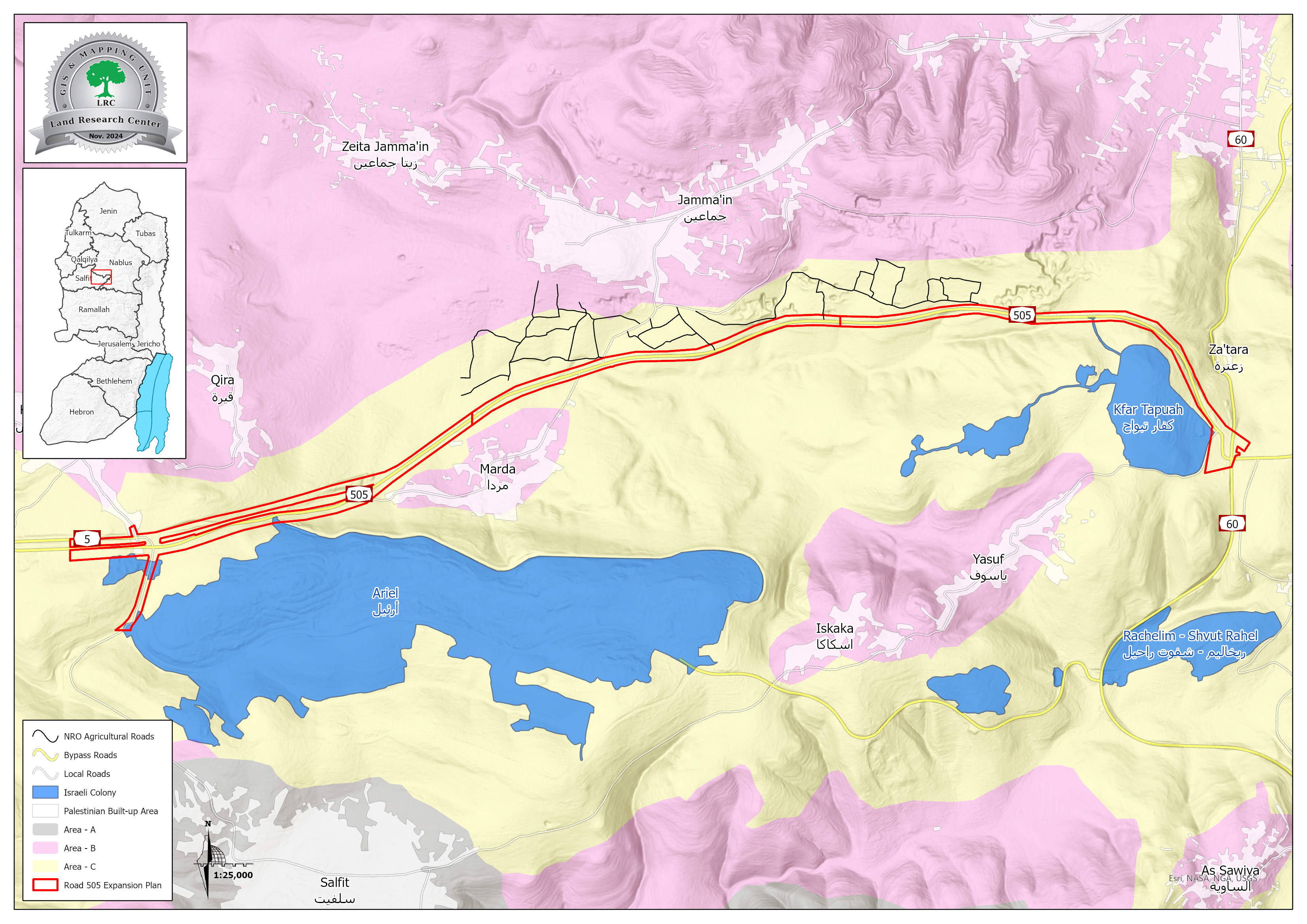
In October 2024, the so-called Deputy Head of the Israeli Civil Administration in the West Bank, "Hillel Roth," issued two military orders to confiscate a total of 546 dunams of land belonging to the villages and towns of Kifl Haris, Marda, Jama’in, Yasuf, and Huwara. The goal is to expand the colonial road No. 505 by adding new lanes for vehicles. The expansion stretches 12 kilometers, starting from the Ariel settlement junction and ending in the Za’tara area, passing through privately owned lands of residents in the aforementioned villages and towns.
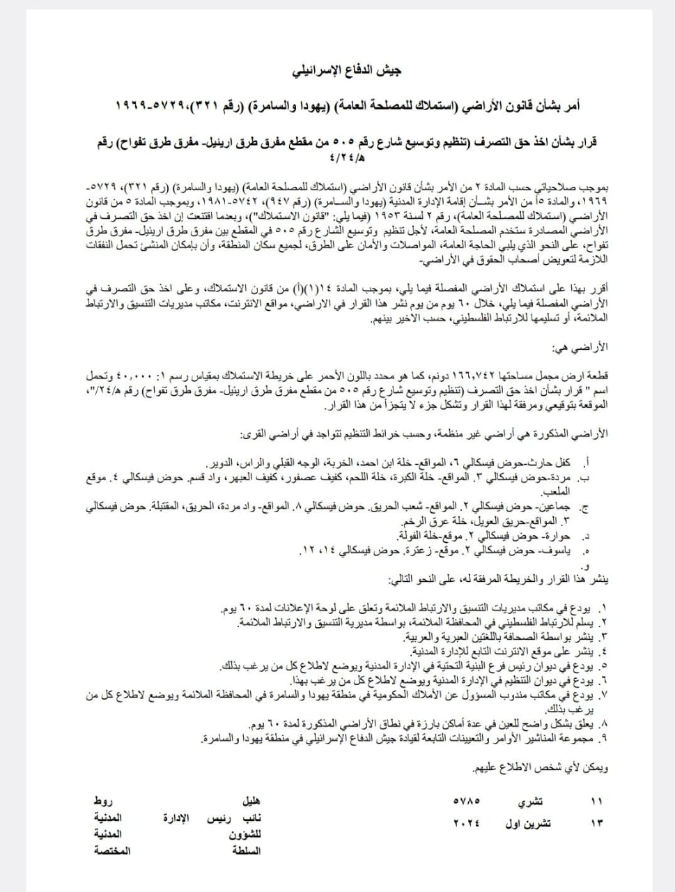
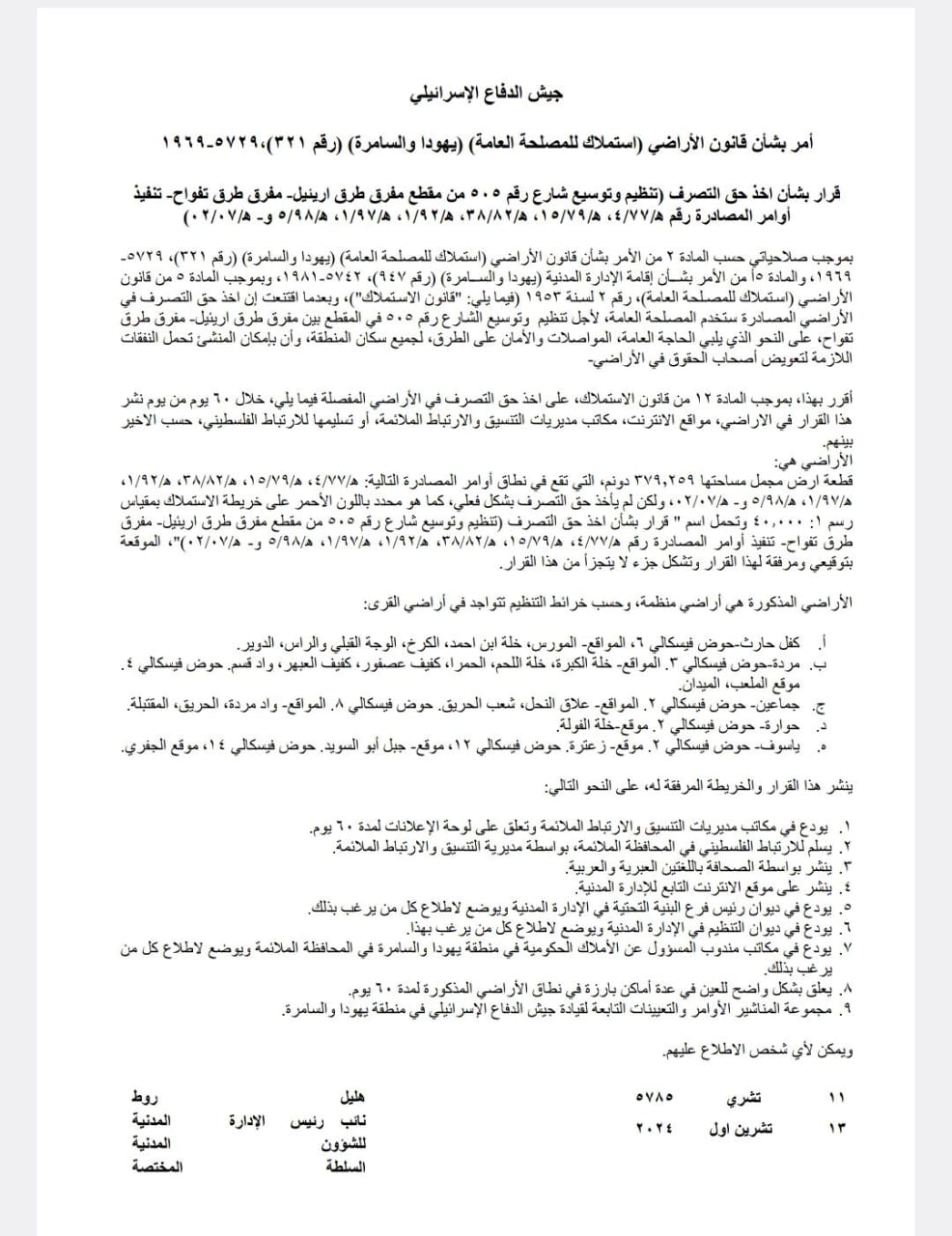
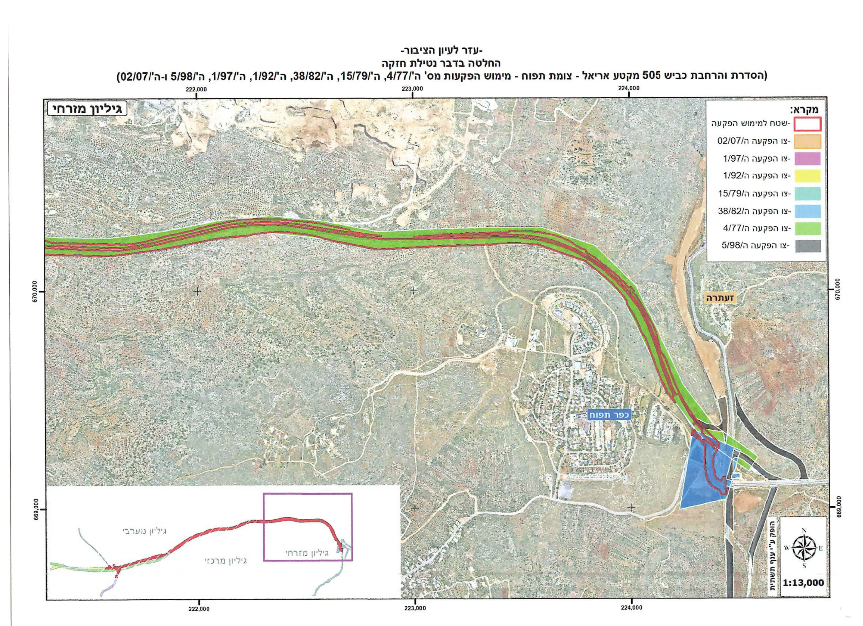
The notifications (military orders) were accompanied by maps outlining the lands to be confiscated under the pretext of expropriation for public interest, as follows:
- First Notification: Titled “Decision Regarding Seizure of Use Rights for the Expansion of Road No. 505 from Ariel Junction to Tafuah Junction” with confiscation orders numbered: H/77/4, H/79/15, H/82/38, H/92/1, H/97/1, H/98/5, and H/7/2. This included the confiscation of 379.2 dunams along the route.
- Second Notification: Titled “Decision Regarding Seizure of Use Rights for the Expansion of Road No. 505 from Ariel Junction to “Tafuh Junction” with confiscation order numbered H/24/4. This included the confiscation of 166.7 dunams along the route.
The total area of land to be confiscated for the road expansion amounts to 546 dunams on both sides of the pre-existing segment. This brings the total land confiscated for this segment—both historically and recently—to approximately 1,220 dunams of privately-owned agricultural lands. This will result in the destruction of vast areas of land and a complete alteration of its features.
It should be noted that the current confiscation involves 166 dunams under the new expropriation order, while the remaining area (approximately 379 dunams) was previously expropriated in the 1970s, 1980s, 1990s, and 2007 but was not implemented. Now, it has been reactivated under the so-called "seizure of use rights."
According to the military orders, the confiscated lands are located in the following villages and areas:
- Kifl Haris: Plot No. (6) in the areas of Khillet Ibn Ahmad, Al-Khirbeh, Al-Wajh Al-Qibli, Al-Ras, and Al-Duwair.
- Marda: Plot No. (3) in the areas of Khillet Al-Kabra, Khillet Al-Lahm, Kafaif Asfour, Wadi Qasem, and Kafaif Al-Abhar; and Plot No. (4) in the Al-Mala’eb area.
- Jama’in: Plot No. (2) in the Shaab Al-Hareeq area.
- Wadi Marda: Plot No. (3) in the areas of Hareeq Al-Oweil and Al-Khalleh.
- Huwara: Plot No. (2) in the Khillet Al-Foula area.
- Yasuf: Plot No. (2) in the Za’tara area, Plot No. (12) in the Jabal Abu Al-Suwaid area, and Plot No. (14) in the Al-Jafri area.
Mr. Mohammad Abd Al-Fattah Ubaid, head of the agricultural committee in Yasuf village, stated:
"According to the attached plans, the confiscation of these lands is essentially a de facto annexation of lands in Salfit Governorate. The proposed road corridor will exceed 36 meters on either side of the road, resulting in a significant loss of the governorate's lands. Additionally, the occupation prohibits construction within 100 meters on both sides of the road, effectively destroying and severely disrupting large agricultural areas. This means that dozens, if not hundreds, of trees will be completely uprooted from the area. Moreover, the road serves as a major facilitator for the alarming colonial expansion in the region, which now threatens all of the governorate's lands.
The military orders and maps illustrating the land confiscation for the colonial road
Nisfat Hassan Al-Khafash, an activist in Salfit Governorate and former head of the Marda Village Council, stated that what is happening amounts to the destruction of Palestinian presence in the area. He explained that the road runs along the northern outskirts of Marda village, turning it into a devastated village. The Ariel settlement already surrounds it from the west and south, the Tafuoh settlement from the east, and now the bypass road from the north. If this plan is implemented, vast areas of the village’s lands will be swallowed up. Moreover, the greatest threat lies in the fact that no fewer than 70 homes in the village are directly or indirectly endangered due to their proximity to the road after its expansion.
In conclusion:
What is happening poses a real and serious threat to the lives of citizens in the area. Since the year 2000, the occupation began expanding this road, starting from the city of Kafr Qasim, occupied in 1948, to the Kifl Haris junction. Now, the occupation is completing the second segment, extending to the Za’tara junction. This development is highly dangerous and serves only the interests of the settlements.
The Israeli occupation uses various forms of military orders as a tool to confiscate Palestinian lands in the occupied West Bank and East Jerusalem under various pretexts. These include building Israeli settlements and outposts, constructing bypass and subsidiary roads, military or security purposes, establishing industrial zones or public service areas supposedly for the "public interest" (which benefits settlers exclusively), designating lands as nature reserves, or removing lands from nature reserve status for colonial expansion. This is part of a systematic policy aimed at consolidating Israeli control over Palestinian lands and expanding settlements and outposts.
The expropriation of Palestinian lands to serve settlements and settlers undermines the historical ownership and use of these lands in Palestine, bypassing Ottoman land laws and defying international law and international legitimacy resolutions. Land confiscation constitutes a clear and serious violation of the 1949 Fourth Geneva Convention, which prohibits an occupying power from transferring parts of its own population to the territories it occupies or making permanent changes to them. Furthermore, the confiscation of lands and their use for settlement purposes violates United Nations resolutions that affirm the illegality of Israeli settlements in occupied territories. Below are key international laws and conventions related to the violation of land and natural resources:
International Covenant on Civil and Political Rights, Article 1:
- All peoples have the right to freely dispose of their natural wealth and resources in pursuit of their own goals, without prejudice to any obligations arising from international economic cooperation based on mutual benefit and international law. In no case may a people be deprived of its own means of subsistence.
Universal Declaration of Human Rights (1948), Article 17:
- Everyone has the right to own property alone as well as in association with others.
- No one shall be arbitrarily deprived of their property.
مشروع: حماية الحقوق البيئية الفلسطينية في مناطق "ج" SPERAC IV - GFFO
Disclaimer: The views and opinions expressed in this report are those of Land Research Center and do not necessarily reflect the views or positions of the project donor; the Norwegian Refugee Council.
إخلاء المسؤولية: الآراء ووجهات النظر الواردة في هذا التقرير هي آراء ووجهات نظر مركز أبحاث الأراضي ولا تعكس بالضرورة وجهات نظر أو مواقف الجهة المانحة للمشروع؛ المجلس النرويجي. للاجئين
