2018-05-15
Violation: notice to clear out 4.700 dunums.
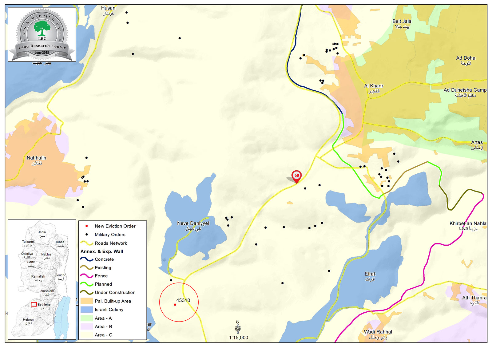
Location: Al-Khader/ Bethlehem.
Date: May , 15, 2018.
Perpetrators: IOF
Victim: Citizen Ibrahim Mohammad Issa.
Details:
May 15 , Tuesday . 4:00 in the afternoon , the occupation's civil administration deliverd a notice to clear out a land for citizen Ibrahim Mohammad Issa on the pretext that it’s a state's land.
Owner (Ibahim Mohammad Issa) told LRC observer:
"While I was working in my land, the occupation's civil administration vehicles came by and delivered me a notice to clear out the property claiming it is a state's land, It is cultivated olive and grapes trees and we constantly take care of it, but it is close to "Neve Daniyyal" settlement, and peace 91 where the new outpost is built"
Issa added:
"I told in charge officer that this is my ancestor's land and it is my property now, He did not listen to me, Greedy illegal settlers constantly brake into it, despite their harassments, I will never give up on my land"
3 years ago, owner Ibrahim Issa cultivated the land with grapes trees, They claimed that this is a violation of a state's property and asked the owner to uproot them within 45 days.
Issa filed an objection to the Occupation's court with the help of "colonization and war resistance committee" to protect his land from confiscation.

Notice to clear out the land
About Al-Khader village:[1]
Al-Khader village is located 4 km from the western side of Bethlehem, it is bordered by Beit Jala and Batir from the north, Hussan and Nahaleen villages from the west, Aldoha, Wadi Rahhal, Beit Jala villages from the east, and Wadi Al-Nees from the south. Its population is 11,960 people in 2017. Its gross area is 8,279 donums; 184 of them are the construction area.
The Israeli colonies have despoils 29 donums from the village's lands; two are colonies existed upon a part of the lands. The first one " Efrat" was constructed in 1979 A.D; they have usurped 5.8 donums, and its population 7037 colonists. The second one " Nafy Danial" eas constructed on 1982A.D; they have usurped 23 donums, and its population is 1073 colonists. A part of which is established upon the village's lands.
The bypass roads number 60 and 375 also despoiled more than 487 donums. In addition to establishing the apartheid upon its lands which causes the demolishing of 280 donums and isolating of 5638 donums behind it. The length of this apartheid existing upon the village's land is 2,805 meters.
The village's lands are classified in accordance with Oslo concord into areas( A,B ,C). Area A composes 10% , Area B 6%, Area C is the greatest area and it is under the total occupation domination, and it composes 84% from the total area. The areas are clarified in donums as following:
Area A (808) donums
AreaB (475) donums
Area C (6,996) donums .
[1] GIS- LRC

The contents of this document is the sole responsibility of LRC and can under no circumstances be regarded as reflecting the position of the European Union