2024-07-15
Colonists Establish New Settlement Outpost on the lands of Duma Village/ South of Nablus
Violation : Establishment of a new settlement outpost.
Location: Duma Village / Nablus Governorate.
Perpetrators: Settlers from “Ma’ale Efraim” settlement.
Affected Party: Residents of Duma Village.
Description:
A group of settlers established a new agricultural settlement outpost on the eastern lands of Duma Village, on lands confiscated by the occupation and handed over to the settlers.
According to field follow up at the site of the violation, the settlers, under the protection of the occupation army, sat up a “farm” consisting of two houses and brought in palm trees to plant on an area of approximately 3 dunums.
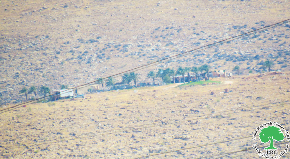
View of a new Settlement outpost Duma’s Lands
The danger of this new outpost lies in its location to the east of Duma village borders. It also located to the east of Duma Village, about 2 km from the village ‘s borders. It also faces the “Ma’ale Efraim” settlement towards this new agricultural outpost, as has which is the same situation that reoccured for many other settlement outposts, which would mean annexing about 500 dunums of grazing lands classified by the occupation as “state lands” at the expense of the village’s lands.
The establishment of this outpost is considered one of the methods invented by the Israel occupation to control agriculture lands and reduce the presence of Palestinians in the area. It is worth noting that the village of Duma is one of the villages directly affected by the repeated violations of the occupation, which have resulted in the confiscation of hundreds of the village’s land.
Duma Village[1]:
Duma covers a total area of approximately 18318 dunums, including 376 dunums of built-up area.
It is bordered to the east by fasayil, to the west by Qarvut and Qusra, to the north by majdal bny fadil, and to the south by Al-Mughayyir, The bypass road No. (458) passes through the village land for 3360 meters, confiscating about 336 dunums under its path. The occupation controls about 130 dunums for Israel army camps. The Oslo Agreement classifies 95% of the village’s land as Area C, which is under full isreali control. The area of zones (B) is 919 dumuns, and the area of zone(C) is 17399 dunums.
[1] LRC -GIS.
مشروع: حماية الحقوق البيئية الفلسطينية في مناطق "ج" SPERAC IV - FCDO
Disclaimer: The views and opinions expressed in this report are those of Land Research Center and do not necessarily reflect the views or positions of the project donor; the Norwegian Refugee Council.
إخلاء المسؤولية: الآراء ووجهات النظر الواردة في هذا التقرير هي آراء ووجهات نظر مركز أبحاث الأراضي ولا تعكس بالضرورة وجهات نظر أو مواقف الجهة المانحة للمشروع؛ المجلس النرويجي. للاجئين