2018-02-14
An Israeli confiscation order on lands to open colonial road
Violation: confiscation order
Location: Burin village-Nablus governorate
Date: February 14, 2018
Perpetrators: The Israeli occupation army
Victims: A number of farmers from Burin
Details:
On February 14, 2018, the Israeli occupation Army High Commander in the West Bank issued the military order number (18/4/T, 5778-2018) to confiscate agricultural lands from Burin village, south of the West Bank city of Nablus.
|
|
|
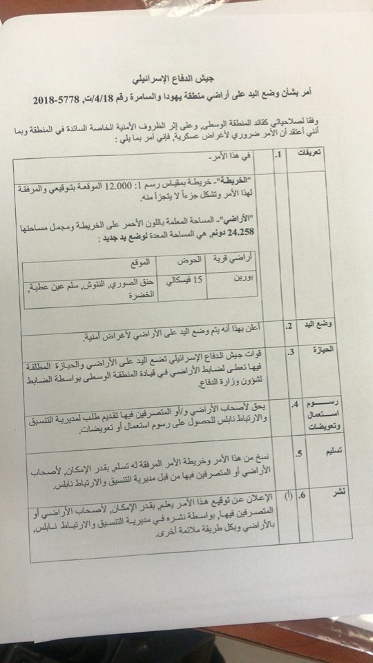
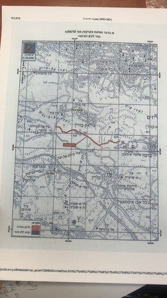
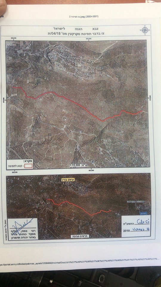
Photo of the military order
According to the military order, the occupation will open a road (1000*20m) for security reasons. Noteworthy, the road will devour a total area of about 24.258 dunums of agricultural lands from several locations namely ( Khaniq Al-Sawari, Lintush, Sillam Ain Atteih, Al-Khaddara, Qitt'an Al-Wi'ir, Khallet Et-Tut and Wi'rit Al-Jardeh).
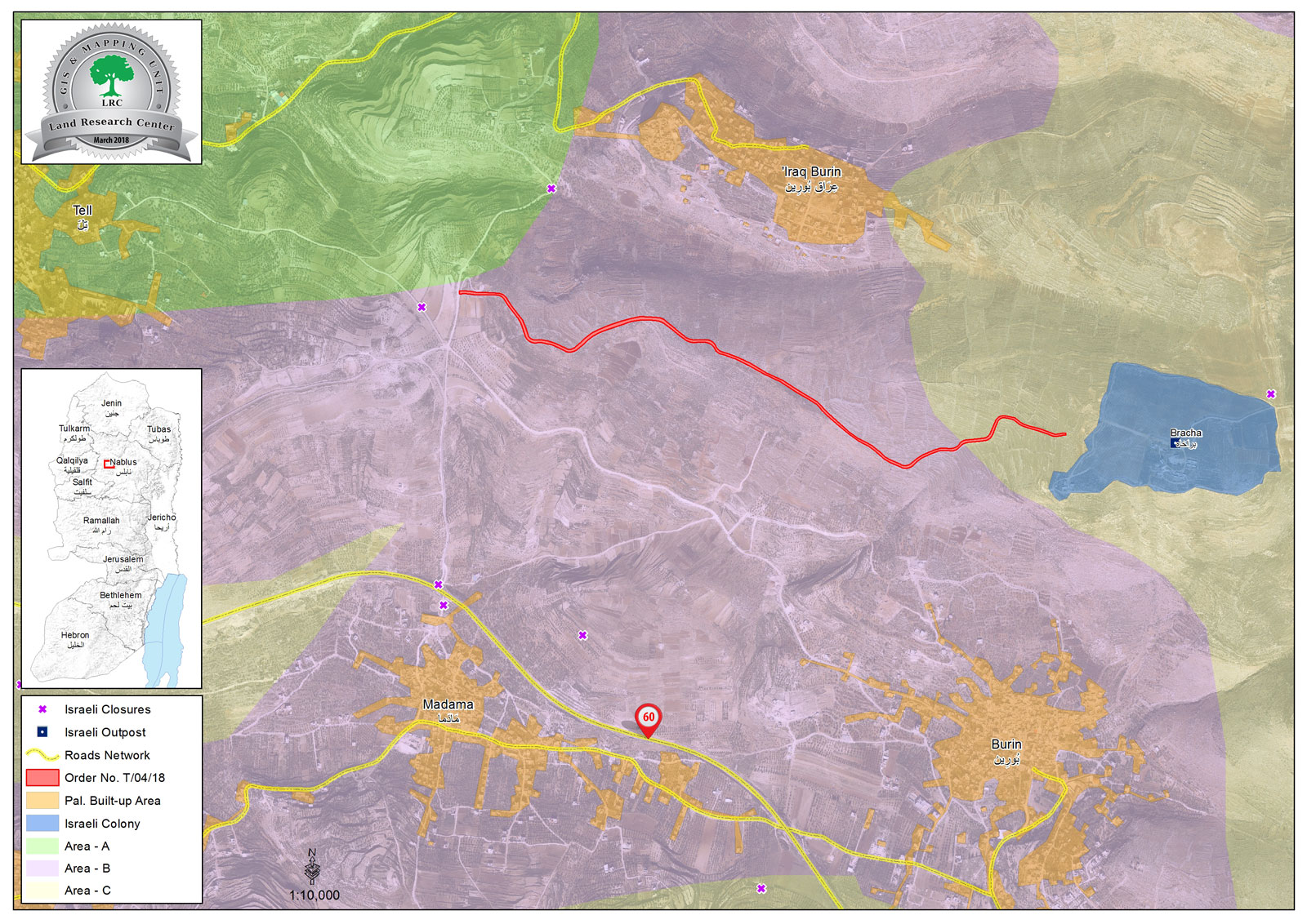
Aerial photo illustrating the route of the proposed road
The chairman of Burin village council, Yahya Qadous, told Land Research Center that the order targets 24 fertile dunums from the area. Opening a road in that area will ban farmers from using and accessing their lands and will deprive herders from grazing land as well.
Qadous said that the village council submitted an objection to the order through The Colonization and Wall Resistance Commission.
Reportedly, 21 farmers are directly affected by the order and that hundreds of dunums will isolated as a result. The farmers are:
Farmer | Location |
Mahmoud Al-Hajj Abed | Lintush |
Mahmoud Sheikh Mousa | |
Mohammad Al-Hajj Abed | |
Mohammad Mohammad | |
Mohammad Abdallah | |
Qasum Mohammad | |
Ali Ibrahim | |
Aqil Al-Hajj Abed | |
Izzat Mahmoud | |
Abdelrahman Izzat Mahmoud | |
Rajeh Al-Hajj Abed | |
Yousef Mohammad | |
Qasim Khalifa | Al-Khaddara |
Khalid Imran | Qitt'an Al-Wi'ir |
Hussni Ibrahim | |
Ismael Darwish | Khallet Et-Tut |
Zeyad Qasim | Khaniq Al-Sawari |
Moustafa Hirmis | |
A housing project | Wi'rit Al-Jardeh |
Ibrahim Khalil |
About Burin:
It is located 8km to the south of Nablus city and is of 10,416 dunums in area, of which 335 dunums are the village’s built-up area. Burin has a total population of 3500 people. Two Israeli colonies are founded on the lands of Burin which are:
- Bracha: it confiscated 205 dunums from Burin’s lands
- Yizhar: it confiscated 150 dunums from Burin’s lands
About Bracha colony:
Bracha was built in 1982 on the Palestinian lands of Kafr Qlil, Burin, and Eraq Burin villages. Around 880 colonists now inhabit the colony.
Eraq Burin has a built-up area of 647 dunums, 291 of which were confiscated for the sake of the colony's expansion. (Source: Geographic Information System- Monitoring Israeli Violations Team- Land Research Center

The contents of this document is the sole responsibility of LRC and can under no circumstances be regarded as reflecting the position of the European Union.